
Flight Plan Series
Download and fly as many flight plans as you like! Just download and unzip the flight plan files and open them in Microsoft Flight Simulator – World Map, or use Simflightplan™ to change your aircraft, modify waypoints or create your own flight plans and share them here. Happy Flying!
Check out the Frequently Asked Questions page or our YouTube Channel.
You can search for specific flight plans by city/place names or ICAO code or even by author name to find your own or your friends flight plans.
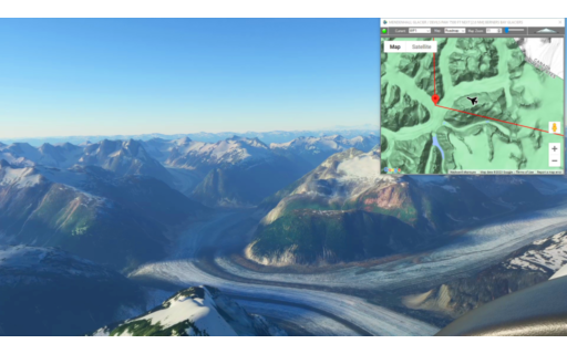
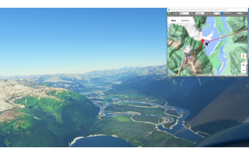
This is the 18th leg of the Pacific Northwest series. It starts at Juneau Int’l and winds over 50 NM of the vast Mendenhall Glacier. Pass over Berners Bay Glaciers before making your way to Skagway Airstrip. Plan ahead to get down quick for the landing.
This is the flight plan used in the YouTube video https://youtu.be/9V3_zq_lpMM
PAJN-PAGY Juneau Int’l to Skagway
DA40-NG Asobo
PAJN: JUNEAU INT’L AIRPORT
WP1: [32.41 NM] MENDENHALL GLACIER / DEVILS PAW
WP2: [20.18 NM] BERNERS BAY GLACIERS
WP3: [19.82 NM] MT POLETICA
WP4: [17.20 NM] SNOWTOP MOUNTAIN
PAGY: [15.35 NM] SKAGWAY AIRSTRIP
Total Distance: 104.99 NM
Flightplan by texstan
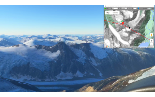
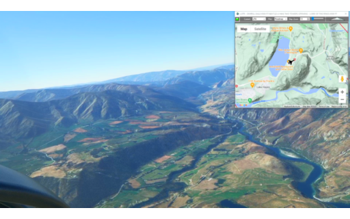
This is the 17th leg of the Pacific Northwest Series and starts in Telegraph Creek, BC. You’ll fly over the glaciers and mountains to the US border and decend at your leisure to Juneau, Alaska.
This is the flight plan from the YouTube video https://youtu.be/iagsBP4JWz8
CBM5-PAJN Telegraph Creek Airport to Juneau Int’l
DA40-NG Asobo
CBM5: TELEGRAPH CREEK AIRPORT
WP1: [29.52 NM] TAHLTAN PEAK
WP2: [13.81 NM] CHEJA PEAK
WP3: [16.83 NM] WHITING PEAK
WP4: [37.66 NM] TAKU INLET
PAJN: [16.02 NM] JUNEAU INT’L AIRPORT
Total Distance: 113.87 NM
Flightplan by texstan
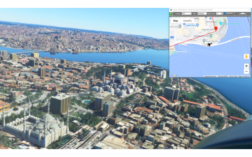
This flight plan flies over Istanbul, Turkey and we created waypoints for Haigia Sophia and Sultan Ahmed Mosques, the Justice Palace and several other points of interest
This is the flight plan used in the YouTube video https://youtu.be/U1BgRh5tPkw
LTBA-LTFJ Ataturk to Sabiha Gokcen
DA40-NG Asobo
LTBA: ATATURK AIRPORT
WP1: [8.04 NM] HAIGA SOFIA & SULTAN AHMED MOSQUES
WP5: [1.06 NM] GALATA BYZANTINE TOWER
WP2: [1.38 NM] DOLMABAHCE PALACE
WP6: [2.58 NM] MINATURK PARK
WP3: [1.52 NM] JUSTICE PALACE
WP4: [3.99 NM] ANATOLIAN FORTRESS
LTFJ: [15.53 NM] SABIHA GOKCEN AIRPORT
Total Distance: 34.14 NM
Flightplan by texstan
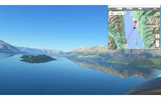
This is the final leg of the Lord of the Rings Series at nearly the southern tip of the South Island of NZ. Start at Glenorchy and fly south to the filming sites of Fangorn Forest and the Anduin River before landing at Anau-Manapouri Airport.
This is the flight plan from the YouTube video https://youtu.be/dPSHXaAknNc
NZGY-NZMO Glenorchy to Manapouri
DA40-NG Asobo
NZGY: GLENORCHY AIRPORT
WP1: [21.85 NM] NORTH MAVORA LAKE
LR1: [14.37 NM] LOTR – FANGORN FOREST
LR2: [11.54 NM] LOTR – RIVER ANDUIN
NZMO: [4.22 NM] ANAU-MANAPOURI AIRPORT
Total Distance: 52.00 NM
Flightplan by texstan
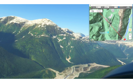
This is the 16th leg of the Pacific Northwest Series and picks up in Wrangell Alaska and winds north through the mountains and over Great Glacier Provincial Park BC. Climb to 10,000 if you want to see the top of Ambition Mountain then land on the dirt runway at Telegraph Creek Airport.
This is the flight plan from the YouTube video https://youtu.be/zKChpoLHg_U
PAWG-CBM5 Wrangell to Telegraph Creek Airport
DA40-NG Asobo
PAWG: WRANGELL AIRPORT
WP1: [26.83 NM] GREAT GLACIER PROVINCIAL PARK
WP2: [10.45 NM] BIG MOUNTAIN
WP3: [16.59 NM] SADDLHORN
WP4: [14.62 NM] AMBITION MOUNTAIN
WP5: [9.66 NM] CROCUS MOUNTAIN
CBM5: [23.71 NM] TELEGRAPH CREEK AIRPORT
Total Distance: 101.89 NM
Flightplan by texstan
This is the 14th leg of the Lord of the Rings Series. There are several filming locations on this leg including Gladden Fields, Isengard and the opening from Two Towers.
NZWF-NZGY Wanaka to Glenorchy
DA40-NG Asobo
NZWF: WANAKA AIRPORT
LR1: [11.61 NM] LOTR – MIDDLE EARTH PANORAMA
LR2: [11.83 NM] LOTR – GLADDEN FIELDS
LR3: [5.47 NM] LOTR – ANDUIN AND ARGONATH
LR4: [5.86 NM] LOTR – DIMRILL DALE
LR5: [26.85 NM] TWO TOWERS OPENING – LORD OF THE RINGS
LR6: [4.96 NM] LOTR – LOTHLORIEN / ISENGARD LOOKOUT
NZGY: [10.20 NM] GLENORCHY AIRPORT
Total Distance: 76.81 NM
Flightplan by texstan
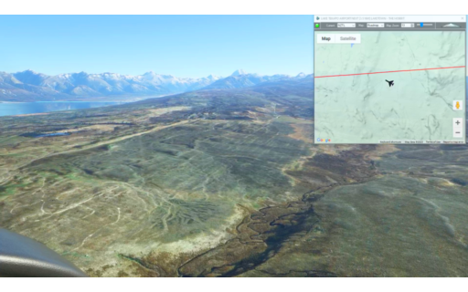
This is the 15th leg of our Pacific Northwest series. It picks up at Stewart Airport in British Columbia and skirts the US-Canada border to Wrangell, Alaska.
This is the flight plan used in the YouTube video https://youtu.be/xI7oLX63SPQ
CZST-KWRZ Stewart to Wrangell
DA40-NG Asobo
CZST: STEWART AIRPORT
WP1: [23.84 NM] MT WILBERT
WP2: [16.70 NM] BLUE LAKE
PAWG: [48.68 NM] WRANGELL AIRPORT
Total Distance: 89.23 NM
Flightplan by texstan
This is the 13th leg of the Lord of the Rings Series. It includes the site of Laketown in The Hobbit film, as well as the location of the Battle of Pelennor Fields.
This is the flight plan used in the YouTube video https://youtu.be/LXNx-Wn6WeU
NZTL-NZWF Lake Tekapo to Wanaka
DA40-NG Asobo
NZTL: LAKE TEKAPO AIRPORT
LR1: [10.94 NM] LAKETOWN – THE HOBBIT
LR2: [15.18 NM] BATTLE OF PELENNOR FIELDS – LORD OF THE RINGS
WP1: [16.04 NM] SNOWY TOP
WP2: [15.66 NM] LINDIS PASS
NZWF: [14.02 NM] WANAKA AIRPORT
Total Distance: 71.86 NM
Flightplan by texstan
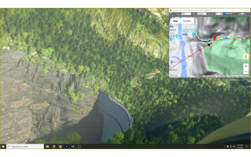
This flight plan contains a selection of waypoints taken from the Mysteries of the Abandoned TV show on Science Channel. Using the latitude and longitude from the show, this flight spans the Italian Alps with 5 locations from the show including the Vajont Dam. There are also many castles and other historic sites to find along the way.
Summary of Mysteries of the Abandoned Episodes:
WP1 Season 3 Episode 5 – Bergamo, Italy N46° 00′ 57.6″, E10° 04′ 26.7″ – Gleno Dam: Built to provide power for but collapsed in 1923, when bombed by anarchists. Built c1917.
WP2 Season 2 Episode 4 – Cresta Croce, Italy N46° 09′ 39.6″ E10° 33′ 31.3″ – Croce Ridge Cannon: 6 ton cannon hauled to the top of a 10,000′ mountain ridge in WWI to defend Italy from Austria.
WP3 Season 1 Episode 3 – 52 Tunnel Road, Italy N45° 46′ 45.33″, E11° 13′ 40.87″ – 4 mile long road carved into the mountains at 6500′, Created to defend Venice from attack via the Alps at Monte Pasubio.
WP4 Season 2 Episode 1 – Belluno, Italy N46° 16′ 02.9″, E12° 19′ 45.1″ – Vajont Dam: Intended hydroelectric dam c1957, breached by landslide in 1963.
WP5 Season 6 Episode 8 – Bovec, Sloveniea N46° 21′ 35.1″, E13° 35′ 16.8″ – Fort Hermann: Built c1900 to defend against Italian
attack from the Bovec Basin below.
This is the flight plan used in the YouTube video https://youtu.be/I0pdJcgh-rg
Mysteries of the Abandoned Locations LIMC-LJBO
DA40-NG Asobo
LIMC: MILAN AIRPORT
WP1: [60.76 NM] GLENO DAM – COLLAPSED 1923 – S3E5-1
WP2: [21.96 NM] CROCE RIDGE CANNON – WWI ERA – S2E4-4
WP3: [36.10 NM] 52 TUNNEL ROAD – S1E3-3
WP4: [54.43 NM] VAJONT DAM – S2E1-2
WP5: [52.46 NM] FORT HERMANN
LJBO: [2.45 NM] BOVEC AIRPORT
Total Distance: 228.17 NM
Flightplan by texstan
This is the next leg of our Pacific Northwest series. It continues from Kincolith Seaplane Base with a water take off and lands at Stewart Airport at the US Canadian border.
CBA3-CZST Gingolx to Stewart
Asobo XCub Floats
CBA3: KINCOLITH SEAPLANE BASE
WP1: [23.41 NM] NASS PEAK
WP2: [23.19 NM] LAVENDAR PEAK
WP3: [25.20 NM] OTTER MOUNTAIN
CZST: [10.78 NM] STEWART AIRPORT
Total Distance: 82.59 NM
Flightplan by texstan