
Flight Plan Series
Download and fly as many flight plans as you like! Just download and unzip the flight plan files and open them in Microsoft Flight Simulator – World Map, or use Simflightplan™ to change your aircraft, modify waypoints or create your own flight plans and share them here. Happy Flying!
Check out the Frequently Asked Questions page or our YouTube Channel.
You can search for specific flight plans by city/place names or ICAO code or even by author name to find your own or your friends flight plans.
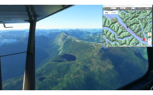
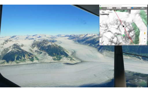
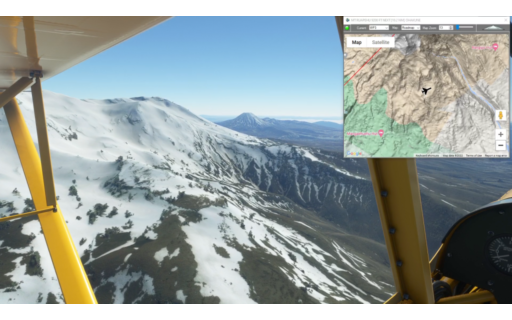
This is the next leg of our Pacific Northwest series. It starts at Dean River Airport and ends with a water landing at Hartley Bay Seaplane Base.
This is the flight plan from the YouTube video https://youtu.be/Kc-GzK-YPi0
YRD-CAY4 Dean River to Hartley Bay Seaplane Base
Asobo XCub Floats
YRD: DEAN RIVER AIRPORT
WP1: [13.83 NM] HALLEY PEAK
WP2: [14.25 NM] KITLOPE PEAK
WP3: [22.27 NM] MARMOR PEAK
WP4: [15.80 NM] WORK ISLAND
CAY4: [25.84 NM] HARTLEY BAY SEAPLANE BASE
Total Distance: 92.01 NM
Flightplan by texstan
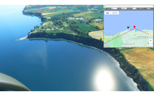
This flight plan follows the coast of France with waypoints for many famous WWII sites.
This is the flight plan used in the YouTube videohttps://youtu.be/7vySnHnQREI
Cherbourg-Mache to Caen
DA40-NG Asobo
LFRC: CHERBOURG-MACHE AIRPORT
WP1: [6.67 NM] BATTERIE DE CAQUERET
WP2: [2.15 NM] BATTERIE DE GATTEVILLE
WP3: [0.67 NM] GATTEVILLE LIGHTHOUSE
WP4: [7.40 NM] ST VAAST LA HOUGUE TOWER
WP5: [5.65 NM] BATTERIE DE CRISBECQ
WP6: [1.16 NM] BATTERIE D’AZEVILLE
WP7: [4.00 NM] NORTH UTAH BEACH / D-DAY MEMORIAL
WP8: [7.12 NM] MAISY BATTERY
WP9: [3.12 NM] LA POINTE DU HOC
WP10: [6.16 NM] OMAHA BEACH
WP11: [5.85 NM] BATTERIE DE LONGUES-SUR-MER
WP12: [3.82 NM] NORMANDY BEACH
WP13: [14.12 NM] DE OUISTREHAM LIGHTHOUSE
LFRK: [10.04 NM] CAEN-CARPIQUET AIRPORT
Total Distance: 77.99 NM
Flightplan by texstan
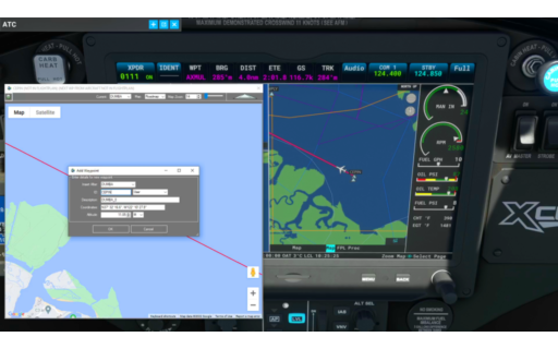
This is the flight plan used to add Nav way points on-the-fly using any glass cockpit.
This is the flight plan used in the YouTube video https://youtu.be/1gRLzRCmpoM
KHWD-KSFO Haward to SF Int’l IFR 28R Approach
Asobo XCub
KHWD: HAYWARD EXECUTIVE AIRPORT
DUMBA: [9.47 NM] DUMBA
CEPIN: [4.23 NM] CEPIN
AXMUL: [4.50 NM] AXMUL
KSFO: [6.20 NM] SAN FRANCISO INT’L
Total Distance: 24.42 NM
Flightplan by texstan
This is the 7th leg of the Lord of the Rings Series and covers 3 filming locations at the southern tip of the North Island before we cross Cook Strait.
This is the flight plan for the YouTube video https://youtu.be/ej36dtU1ehg
NZWN-NZWB Wellington to Marlborough
DA40-NG Asobo
NZWN: WELLINGTON INT’L AIRPORT
LR1: [19.00 NM] LOTR – GARDENS OF ISENGARD
LR2: [5.30 NM] LOTR – RIVENDELL
LR3: [23.41 NM] LOTR – PATHS OF THE DEAD
NZWB: [62.12 NM] MARLBOROUGH (WOODBOURNE) AIRPORT
Total Distance: 109.83 NM
Flightplan by texstan
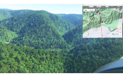
This is the next leg of our Pacific Northwest series. It’s a short leg from Bella Coola to Houston Airstrip (Google Maps has it as Dean River Airport, but at the time this flight plan was created it was Houston Airstrip in MSFS).
This is the flight plan used in the YouTube video https://youtu.be/YHrwj6jljDE
CYBD-YRD Bella Coola to Houston
Asobo XCub Floats
CYBD: BELLA COOLA AIRPORT
WP1: [12.46 NM] MT SAUNDERS
WP2: [14.49 NM] CYRILLIC PEAK
YRD: [10.01 NM] HOUSTON AIRSTRIP
Total Distance: 36.97 NM
Flightplan by texstan
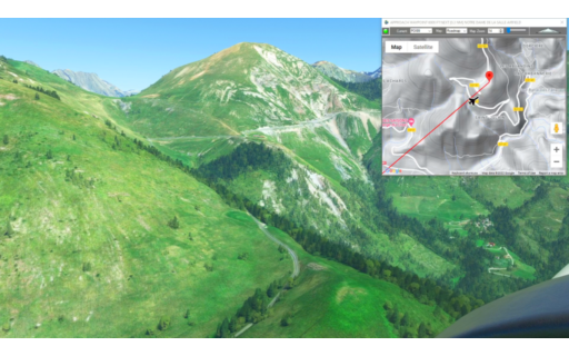
This flight plan is a landing practice flight for Notre Dame de la Sallette airfield from the Mont Blanc Bush Trip activity.
See the YouTube video for more information https://youtu.be/4FoLXGbDZDg
Note: In the video the DA40-NGX Improvement Mod has been used which makes the DA40 much easier to fly – you can check it out at https://flightsim.to/file/2738/da40-ngx-project
Thank you to mrtommymxr for the excellent mod.
LFPS Landing Practice
DA40-NG Asobo
POI99: APPROACH WAYPOINT
LFPS: [2.32 NM] NOTRE DAME DE LA SALLETTE AIRFIELD
Total Distance: 2.32 NM
Flightplan by texstan
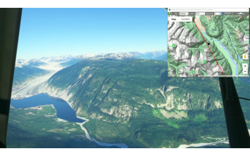
This is the 9th leg of our Pacific Northwest series. It starts with a water takeoff from Knight Inlet and flies through the stunning glaciers and mountains of British Columbia Canada, landing in scenic Bella Coola.
This is the flight plan used in the YouTube video https://youtu.be/vgzWn-9FSTc
WTO-CYBD Knight Inlet to Bella Coola
Asobo XCub Floats
WTO: KNIGHT INLET
WP1: [26.19 NM] FANG PEAK
WP2: [8.97 NM] MT PELLETIER
WP3: [17.34 NM] MT VERA
WP4: [9.37 NM] CERBERUS MOUNTAIN
WP5: [26.20 NM] BIG SNOW MOUNTAIN
CYBD: [9.72 NM] BELLA COOLA AIRPORT
Total Distance: 97.82 NM
Flightplan by texstan
This is the 6th leg of our New Zealand / Lord of the Rings series. This one starts in Whanganui and continues along the west coast to Wellington. Along the way we pass the filming locations for Osgilath Wood, Battle of Pellenor Fields and Hobbits Hideaway before landing at Wellington Int’l.
This is the flight plan used in the video https://youtu.be/OQsY8ZYh2ss
Note: In the video the DA40-NGX Improvement Mod has been used which makes the DA40 much easier to fly – you can check it out at https://flightsim.to/file/2738/da40-ngx-project
Thank you to mrtommymxr for the excellent mod.
NZWU-NZWN Whanganui to Wellington Int’l
DA40-NG Asobo
NZWU: WHANGANUI AIRPORT
LR1: [36.93 NM] LOTR – OSGILIATH WOOD
LR2: [25.99 NM] LOTR – BATTLE OF THE PELENNOR FIELDS
LR3: [21.70 NM] MT VICTORIA / LOTR – HOBBITON WOODS
NZWN: [2.09 NM] WELLINGTON INT’L AIRPORT
Total Distance: 86.72 NM
Flightplan by texstan
This is the 5th leg of our New Zealand / Lord of the Rings series. While there are no filming locations on this leg we fly the spectacular views of the Tongarro National Park and wind along the Whanganui River to the Pacific coast.
This is the flight plan used in the YouTube video https://youtu.be/AeW4HG7qgpw
NZTM-NZWU Taumarunui to Whanganui
DA40-NG Asobo
NZTM: TAUMARUNUI AIRPORT
WP1: [12.72 NM] WHANGANUI RIVER
WP2: [13.40 NM] MT NGAURUHOE
WP3: [8.16 NM] MT RUAPEHU
WP4: [11.41 NM] OHAKUNE
WP5: [15.56 NM] MATAHIWI
WP6: [12.55 NM] WHANGANUI RIVER
NZWU: [10.38 NM] WHANGANUI AIRPORT
Total Distance: 84.22 NM
Flightplan by texstan

This flight plan has waypoints for several famous landmarks in Paris (you can add more if you want). It is intended to be flown on autopilot at about 1000 feet so that you can exit the cockpit and fly the drone while you see the siights. It is recommended that you connect a game controller (xbox, ps4, etc) to make flying the drone easier, but it can be controlled from the keyboard as well.
This is the flight plan used in the YouTube video https://youtu.be/vqA0Lf5qUkA
LFPO to LFPB Orly to Le Bourget
Cessna Skyhawk G1000 Asobo
LFPO: ORLY
WP1: [8.17 NM] NOTRE DAME
WP2: [1.27 NM] THE LOUVRE
WP3: [2.03 NM] ARC DE TRIOMPHE
WP4: [1.71 NM] EIFFEL TOWER
WP5: [1.19 NM] HOTEL DES INVALIDES
LFPB: [8.55 NM] LE BOURGET
Total Distance: 22.94 NM
Flightplan by texstan