
Flight Plan Series
Download and fly as many flight plans as you like! Just download and unzip the flight plan files and open them in Microsoft Flight Simulator – World Map, or use Simflightplan™ to change your aircraft, modify waypoints or create your own flight plans and share them here. Happy Flying!
Check out the Frequently Asked Questions page or our YouTube Channel.
You can search for specific flight plans by city/place names or ICAO code or even by author name to find your own or your friends flight plans.
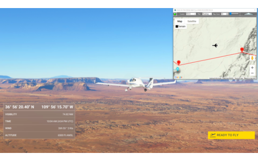
This is the same flight plan as the 2nd leg of the Navajo Volcanic Field series. But in this one, the flight settings are adjusted to start with the aircraft in flight over Monument Valley at 6,500 feet.
This is the flight plan used in the video https://youtu.be/Kvev4QY12wg
Shiprock Airstrip to Olijato Regional
DA40-NG Asobo
5V5: SHIPROCK AIRSTRIP
POI09: [13.61 NM] HWY 64
POI10: [10.63 NM] AZ BORDER/PASTORA PEAK
POI11: [17.75 NM] WILLOW SPRING WASH
POI12: [10.51 NM] CHINLE CREEK
POI13: [8.04 NM] PASS IN THE RIDGE
POI14: [3.95 NM] ROOSTER ROCK
POI15: [7.12 NM] SENTINAL MESA/MONUMENT VALLEY
POI16: [3.04 NM] THE STAGECOACH
POI17: [5.76 NM] FORREST GUMP POINT
POI18: [7.07 NM] EAGLE MESA
POI19: [7.03 NM] TRAIN ROCK
UT25: [5.09 NM] OLJATO REGIONAL AIRPORT
Total Distance: 99.64 NM
Flightplan by texstan
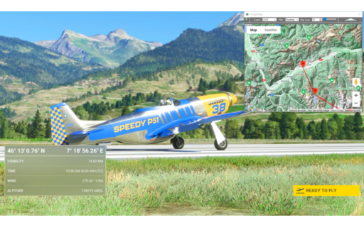
LSGS-LSPM Sion to Ambri
P51-D Mustang Asobo Reno
This is the flight plan used in the YouTube video https://youtu.be/-y08dON_O8o
LSGS: Sion
POI13: [8.95 NM] Grande Dixence Dam/Lac Des Dix
POI14: [12.32 NM] Matterhorn
POI15: [5.28 NM] Gornergrat South Observatory
POI16: [4.41 NM] Monte Rosa
DOM: [9.49 NM] Dom
VISP: [11.86 NM] Visp
POI17: [12.07 NM] Aletsch Glacier
POI18: [7.37 NM] Sphinx Observatory
EIGER: [1.98 NM] Eiger
POI19: [17.43 NM] Tiefenstock
POI20: [9.72 NM] Airolo
LSPM: [3.62 NM] Ambri
Total Distance: 104.58 NM
Flightplan by texstan
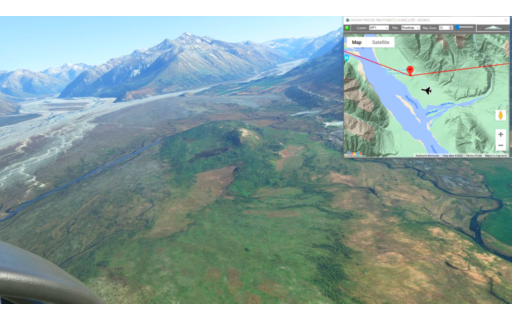
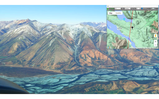
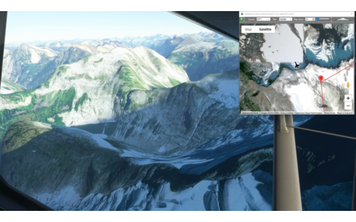
This is the 12th leg of the Lord of the Rings Series. This one includes the site of Edoras from the Lord of the Rings, but also a fly-by of Mt Cook at 12,000 feet.
This is the flight plan from the YouTube video https://youtu.be/FvW86YARTRk
Note: In the video the DA40-NGX Improvement Mod has been used which makes the DA40 much easier to fly – you can check it out at https://flightsim.to/file/2738/da40-ngx-project
Thank you to mrtommymxr for the excellent mod.
MTH-NZTL Pudding Hill to Lake Tekapo
DA40-NG Asobo
NZPH: PUDDING HILL AERODROME
WP1: [10.83 NM] MOUNT TAYLOR
LR1: [18.66 NM] LOTR – EDORAS
WP2: [14.43 NM] MOUNT DARCHIAC
WP3: [13.76 NM] MINARETS
WP4: [7.82 NM] AORAKI / MOUNT COOK
NZTL: [27.49 NM] LAKE TEKAPO AIRPORT
Total Distance: 93.01 NM
Flightplan by texstan
This is the 11th leg of the Lord of the Rings Series. The route starts in Greymouth and ends at Pudding Hill Aeordrome at the foot of Mt Hutt. Along the way fly over Mt Olympus where the aerial shots of Sarauman’s spies flying over the Fellowship in the Lord of the Rings were filmed.
This is the flight plan used in the YouTube video https://youtu.be/tlywuLHBwjI
Note: In the video the DA40-NGX Improvement Mod has been used which makes the DA40 much easier to fly – you can check it out at https://flightsim.to/file/2738/da40-ngx-project
Thank you to mrtommymxr for the excellent mod.
NZGM-MTH Greymouth to Pudding Hill
DA40-NG Asobo
NZGM: GREYMOUTH AIRPORT
WP1: [25.90 NM] MOUNT NEWTON
WP2: [7.57 NM] MT MURCHESON
LR1: [14.76 NM] MT OLYMPUS / THE PINNACLES
NZPH: [24.30 NM] PUDDING HILL AERODROME
Total Distance: 72.54 NM
Flightplan by texstan
This is the 10th leg of the Lord of the Rings Series. Take off from Murcheson Aerodrome and fly past Mt Victoria before following the Grey River to the Pacific Coast.
This is the flight plan from the YouTube video https://youtu.be/xCar2raf4Gs
NZMR-NZGM Murchison to Greymouth
DA40-NG Asobo
NZMR: MURCHISON AERODROME
WP1: [16.61 NM] MT VICTORIA
WP2: [26.15 NM] GREY RIVER
NZGM: [22.59 NM] GREYMOUTH AIRPORT
Total Distance: 65.36 NM
Flightplan by texstan
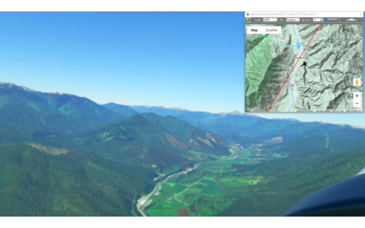
This is the next leg of our Pacific Northwest series. It picks up at NW Terrace Regional with another water landing in the X-Cub at Kincolith Seaplane Base.
CYXT-CBA3 NW Terrace to Kincolith Seaplane Base
Asobo XCub Floats
CYXT: NW TERRACE REGIONAL
WP1: [21.68 NM] MT WILLIAM BROWN
WP2: [11.69 NM] MT LEIGHTON
WP3: [11.04 NM] MT VOSHELL
CBA3: [21.97 NM] KINCOLITH SEAPLANE BASE
Total Distance: 66.39 NM
Flightplan by texstan
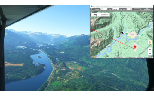
This is the 12th leg of our Pacific Northwest series. Take off from Hartley Bay Seaplane Base and land at NW Terrace Regional.
*NOTE: You MUST select an aircraft with floats BEFORE loading this flight plan in World Map to work around an issue where Flight Simulator doesn’t enable the Fly button.
This is the flight plan used in the YouTube video https://youtu.be/B81NuRXDpFo
CAY4-CYXT Hartley Bay to NW Terrace
Asobo XCub Floats
CAY4: HARTLEY BAY SEAPLANE BASE
WP1: [35.34 NM] TENTACLE PEAK
WP2: [14.98 NM] MT HOLT
CYXT: [24.55 NM] NW TERRACE REGIONAL
Total Distance: 74.88 NM
Flightplan by texstan
This is the 9th leg of the Lord of the Rings Series. It includes the filming location for Chetwood Forest from the Lord of the Rings films. Then heads south over The Twins and Mt Owen before landing on the grass strip at Murcheson Aerodrome.
This is the flight plan used in the YouTube video https://youtu.be/XftoZLcA0jg
Note: In the video the DA40-NGX Improvement Mod has been used which makes the DA40 much easier to fly – you can check it out at https://flightsim.to/file/2738/da40-ngx-project
Thank you to mrtommymxr for the excellent mod.
NZNS-NZMR Nelson to Murchison
Asobo Savage Cub
NZNS: NELSON AIRPORT
LR1: [22.46 NM] LOTR – CHETWOOD FOREST
WP1: [10.62 NM] COBB RESERVOIR
WP2: [7.61 NM] THE TWINS
WP3: [19.09 NM] MOUNT OWEN
NZMR: [17.74 NM] MURCHISON AERODROME
Total Distance: 77.54 NM
Flightplan by texstan
This flight plan is the 8th leg of the Lord of the Rings Series. It’s a short flight from Blenheim to Nelson NZ at the scenic northern end of the South Island. Nelson, NZ is also where the jeweler is located that made the ring for the Lord of the Rings films.
This is the flight plan for the YouTube video https://youtu.be/ZC-FPZoPr6w
NZWB-NZNS Blenheim to Nelson
Asobo Savage Cub
NZWB: MARLBOROUGH AIRPORT
WP1: [15.70 NM] CULLEN POINT
WP2: [17.01 NM] CABLE BAY
NZNS: [11.88 NM] NELSON AIRPORT
Total Distance: 44.60 NM
Flightplan by texstan
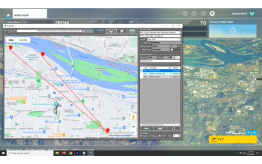
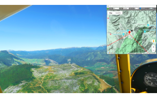
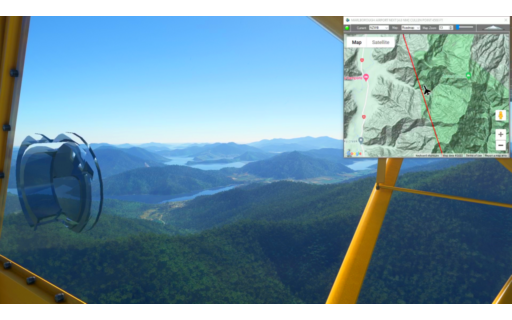
This flight plan is from Portland Int’l to the crash site of United Flight 173 (featured in Air Disasters on the Smithsonian Channel).
This is the flight plan used in the YouTube video https://youtu.be/PEQsEE69ce0
KPDX – United Flight 173 Crash Site
Asobo XCub
KPDX: PORTLAND INT’L
USR01: [6.74 NM] UNITED 173 CRASH SITE
KPDX: [5.28 NM] PORTLAND INT’L
Total Distance: 12.02 NM
Flightplan by texstan