
Flight Plan Series
Download and fly as many flight plans as you like! Just download and unzip the flight plan files and open them in Microsoft Flight Simulator – World Map, or use Simflightplan™ to change your aircraft, modify waypoints or create your own flight plans and share them here. Happy Flying!
Check out the Frequently Asked Questions page or our YouTube Channel.
You can search for specific flight plans by city/place names or ICAO code or even by author name to find your own or your friends flight plans.
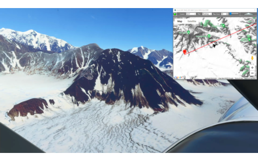
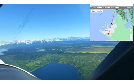
This is the 24th leg of the Pacific Northwest Series. We resume by taking off from the glacier at the foot of Mt Logan and flying around it’s eastern flank. Fly over the remote Kluane National Park and over Kluane Lake before landing at Burwash Landing Airport.
This is the flight plan used in the YouTube video https://youtu.be/o8ElbsZuHcw
GLA1-CYHT Glacier Takeoff to Burwash
Asobo XCub Skis
GLA1: GLACIER TAKE OFF
WP1: [43.07 NM] GLACIER
WP2: [12.44 NM] MT MAXWELL
WP3: [12.79 NM] VULCAN MOUNTAIN
WP4: [18.72 NM] KLUANE LAKE
CYDB: [16.50 NM] BURWASH LANDING AIRPORT
Total Distance: 103.53 NM
Flightplan by texstan
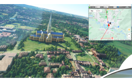
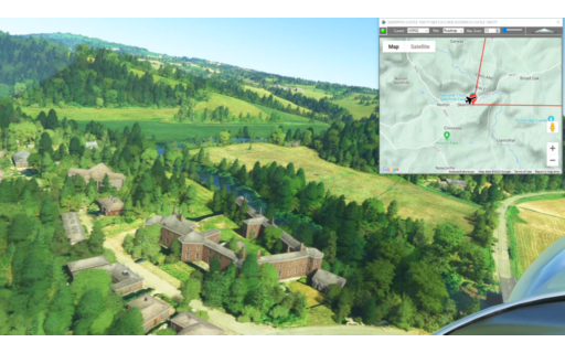
This flight plan is a collection of places from the Mysteries of the Abandoned TV show on Science Channel, located in the south of England. MSFS World Map points of interest for the area are also included as waypoints, including Stonehenge and Salisbury Cathedral in addition to a number of famous landmarks found on Google Maps. The flight plan uses the NX-Cub and it is a 140 NM trip so watch your fuel tanks in-flight, but you’ll start full. You can also use your Repair button to refuel in flight or stop at one of several airports the flight plan passes and refuel on the ground if necessary. If you stick to the route you should have enough.
This is the flight plan used in the YouTube video https://youtu.be/zPt7LcSztAw
*Waypoint number definitions: POIxx are MSFS World Map points of interest, WPxx are simply Google maps landmarks, and the S prefixed numbers are from the Mysteries of the Abandoned TV show on Science Channel. The format is (S)eason number, (E)pisode number and the segment. For example, to watch the segment from the show for the waypoint S5E5-1, you’d want Season 5, Episode 5, segment 1 meaning the very first story in that episode.
MOTA Locations Plus MSFS Points of Interest
Asobo NXCub
EGCX: LOWER MANOR FARM AIRSTRIP
WP1: [3.18 NM] NOTHE FORT
WP2: [2.34 NM] PORTLAND CASTLE
S5E5-1: [1.60 NM] BREAKWATER FORT / PORTLAND CASTLE
WP3: [8.44 NM] LULWORTH CASTLE WAREHAM
S3E7-1: [1.88 NM] VILLAGE OF TYNEHAM – WWII BOMBING RANGE
WP4: [12.41 NM] KINGSTON LACY
POI01: [17.64 NM] SALISBURY CATHEDRAL
POI02: [6.91 NM] STONEHENGE
POI03: [20.71 NM] WOLVESEY CASTLE
S6E4-1: [17.80 NM] ROYAL HOSPITAL HASLAR
POI04: [0.86 NM] SPINNAKER TOWER
WP5: [0.18 NM] HMS WARRIOR
POI05: [36.87 NM] BRIGHTON PALACE PIER
POI06: [0.59 NM] BRITISH AIRWAYS i360
EGOI: [6.15 NM] SWANBOROUGH FARM AIRSTRIP
Total Distance: 137.62 NM
Flightplan by texstan
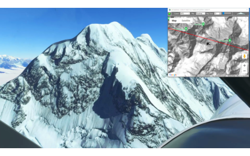
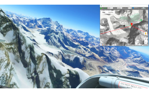
This is the 23rd leg of the Pacific Northwest Series, flying the XCub with skis so that we can land on a glacier at the foot of Mt Logan in British Columbia. This leg takes off from Icy Bay on the Pacific Coast and skirts the US-Canada border before turning north for a glacier landing.
This is the flight plan used in the YouTube video https://youtu.be/NaiSEgcXpr8
19AK-GLA1 Icy Bay to Mt Logan BC
Asobo XCub Skis
19AK: ICY BAY AIRPORT
WP1: [14.35 NM] TAAN FJORD
WP2: [13.16 NM] HAYDON PEAK
WP3: [10.70 NM] MT BERING
WP4: [8.88 NM] MT EATON
GLA1: [9.76 NM] MT LOGAN GLACIER LANDING
Total Distance: 56.86 NM
Flightplan by texstan
This flight plan starts in Kathmandu and has waypoints for several temples and stupas in Kathmandu before starting the long climb into the Himalayas. Climb to 20,000 to clear the China-Nepal border and continue climbing to the highest point on Earth at nearly 30,000 feet. After checking out the base camps along the Nepalese route to the summit, descend rapidly to land at Tenzing-Hillary Airport at 9,250 feet.
This is the flight plan used in the YouTube video https://youtu.be/P9Ywru1xCno
VNKT-VNLK Tribihuvan to Tenzing-Hillary
Pilatus PC-6 Gauge Skis
VNKT: TRIBHUVAN AIRPORT
USR01: [0.84 NM] PASHUPATINATH TEMPLE
USR02: [2.23 NM] DURBAR SQUARE
USR03: [0.21 NM] SETO MACHHINDRA NATH TEMPLE
USR04: [1.15 NM] SWOYAMBHU MAHACHAITYA
USR05: [3.78 NM] BUDDHA STUPA
USR06: [3.52 NM] CHANGUNARAYAN TEMPLE
USR07: [5.70 NM] JAMCHEN STUPA
USR08: [71.43 NM] CHO OYU MOUNTAIN
USR09: [15.33 NM] MT EVEREST
VNLK: [20.83 NM] TENZING-HILLARY AIRPORT
Total Distance: 125.07 NM
Flightplan by texstan
This is the 22nd leg of the Pacific Northwest Series. Take off from Yakutat Airport and fly over Hubbard Glacier before climbing to 13,500 to the peak of Mt. Cook (Alaska). Then drift down over the glaciers and inlets to land at Icy Bay.
This is the flight plan used in the YouTube video https://youtu.be/Mm-FOclbQH8
PAYA-19AK Yakutat to Icy Bay
Asobo XCub
PAYA: YAKUTAT AIRPORT
WP1: [34.15 NM] HUBBARD GLACIER
WP3: [19.03 NM] MT COOK
WP4: [22.43 NM] OILY LAKE
19AK: [29.86 NM] ICY BAY AIRPORT
Total Distance: 105.49 NM
Flightplan by texstan

This flight plan is an example of how you can save any aircraft with specific avionics and flight control settings, then use Flightplan to reuse that aircraft configuration as many times as you want. The example uses the Beechcraft King Air, fully started with lights and avionics turned on, but at a parking spot ready to taxi. As an example the Wind Vector display setting is saved in the PFD as well. This choice of airports was arbitrary.
This is the flight plan from the YouTube video with the same title https://youtu.be/pEBAFmg2XU8
See the FAQ Article for more information.
KPDX-KSFO King Air Ready-to-Taxi
Beechcraft King Air 350i Asobo
KPDX: PORTLAND INT’L
KSFO: [478.35 NM] SAN FRANCISCO INT’L
Total Distance: 478.35 NM
Flightplan by texstan
This is the final leg of the Welsh Castles homegrown Bush Trip, from Shobdon to Gloucestershire. Along the way fly over Skinfirth and Goodrich Castles and explore the many others off the direct flight path.
This is the flight plan used in the YouTube video https://youtu.be/vXGGgaVxInM
EGBS-EGBJ Shobdon to Gloucestershire
Asobo NXCub
EGBS: SHOBDON AERODROME
USR01: [7.78 NM] HAMPTON COURT CASTLE
USR02: [17.68 NM] SKENFRITH CASTLE
USR03: [6.45 NM] GOODRICH CASTLE
EGBJ: [16.65 NM] GLOUCESTERSHIRE AIRPORT
Total Distance: 48.57 NM
Flightplan by texstan

This is the penultimate leg of the Wales Bush Trip and includes Rowton and Powis Castles, along with several others both on and off the flight plan. Take off from Whittington Airport (AKA Rednal) and wind south along the Welsh-English border to Shobdon Aerodrome.
This is the flight plan used in the YouTube video https://youtu.be/Gm-BVwNg1fo
EGAZ-EGBS Whittington to Shobdon
Asobo NXCub
EGAZ: WHITTINGTON AIRPORT
USR01: [8.46 NM] ADMIRAL RODNEYS PILLAR
USR02: [4.58 NM] ROWTON CASTLE
USR03: [9.43 NM] POWIS CASTLE AND GARDEN
USR04: [7.07 NM] DOLFORWYN CASTLE
USR05: [22.55 NM] CROFT CASTLE
EGBS: [3.70 NM] SHOBDON AERODROME
Total Distance: 55.83 NM
Flightplan by texstan
This is the 20th leg of the Pacific Northwest Series. It picks up at Alsek River and winds along the mountains and glaciers of the US – Canada border. To avoid probles with newer Garmin Cockpits you may want to change the aircraft to a non-Garmin glass cockpit (such as the X-Cub) or download the DA40-NGX mod that I used in the video here https://flightsim.to/file/2738/da40-ngx-project
This is the flight plan used in the video https://youtu.be/8XWEdZXrmJA
AK76-CYHT East Alsek River to Haines Junction Airstrip
DA40-NG Asobo
AK76: EAST ALSEK RIVER AIRSTRIP
WP1: [28.11 NM] BATTLE PEAK
WP2: [15.15 NM] MT VIKITSKY
WP3: [14.94 NM] MT BLACKADAR
WP4: [30.28 NM] LOWELL PEAK
WP5: [13.21 NM] INUPIAT PEAK / LOWY PEAK
CYHT: [38.58 NM] HAINES JUNCTION AIRSTRIP
Total Distance: 140.31 NM
Flightplan by texstan
This flight plan contains a collection of waypoints in and around Berlin, Germany taken from the Mysteries of the Abandoned TV show on Science Channel. There are also waypoints for the MSFS World Map points of for convenience.
This is the flight plan used in the YouTube video https://youtu.be/QsRv1KRtK5w
ED15-EDAZ MOTA Locaitons and MSFS Points of Interest
Asobo NXCub
ED15: KREMMEN-HOHENBRUCH
S5E2-1: [6.73 NM] NAZI SS BAKERY / SACHSENHAUSEN
S4E9-1: [17.07 NM] 1936 OLYMPIC VILLAGE
S2E5-1: [8.81 NM] TEUFELSBERG HILL RADOMES
POI05: [1.03 NM] OLYMPIC STADIUM
POI01: [2.09 NM] CHARLOTTENBURG PALACE
POI02: [2.05 NM] TIERGARTEN
POI03: [0.85 NM] REICHSTAG
POI04: [0.25 NM] BRANDENBURG GATE
POI06: [0.81 NM] BERLIN CATHEDRAL / MUSEUM ISLAND
POI07: [0.28 NM] ST NICHOLAS CHURCH
POI08: [0.29 NM] BERLIN TELEVISION TOWER
S4E8-1: [2.87 NM] STASSI PRISON / HQ COMPLEX
S5E6-2: [14.04 NM] RANGSDORF AIRFIELD
S4E3-2: [5.50 NM] ZEPPELIN BUNKER – NAZI & SOVIET ERA
S3E8-2: [1.93 NM] RED ARMY HQ – SOVIET ERA
S3E1-2: [21.20 NM] BEELITZ SANITORIUM – TB HOSTPITAL c1898
EDAZ: [8.99 NM] SCHONHAGEN AIRPORT
Total Distance: 94.86 NM
Flightplan by texstan