
Flight Plan Series
Download and fly as many flight plans as you like! Just download and unzip the flight plan files and open them in Microsoft Flight Simulator – World Map, or use Simflightplan™ to change your aircraft, modify waypoints or create your own flight plans and share them here. Happy Flying!
Check out the Frequently Asked Questions page or our YouTube Channel.
You can search for specific flight plans by city/place names or ICAO code or even by author name to find your own or your friends flight plans.
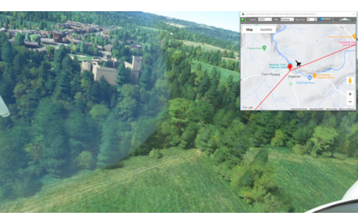
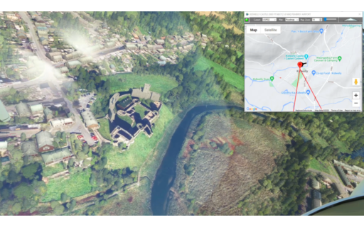
This is the seventh leg of the Wales Bush Trip and includes Flint Castle, Chester Cathedral and several other points of interest.
This is the flight plan used in the YouTube video https://youtu.be/wPHxkv25hig
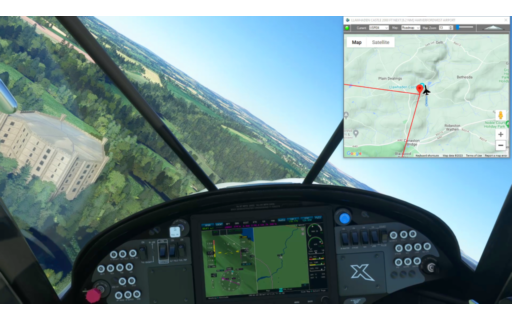
EGCE-EGAZ Bryngwyn to Whittington
Asobo NXCub
EGCE: BRYNGWYN BACH AIRFIELD
USR20: [8.38 NM] FLINT CASTLE
USR21: [3.84 NM] EWLOE CASTLE
USR22: [6.33 NM] CHESTER CATHEDRAL / EASTGATE CLOCK
USR23: [15.10 NM] PONTCYSYLITE AQUEDUCT
USR24: [2.68 NM] CHIRK AQUEDUCT
EGAZ: [6.83 NM] WHITTINGTON AIRPORT
Total Distance: 43.19 NM
Flightplan by texstan
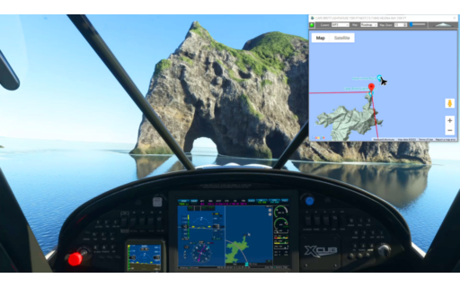
This is actually the same flight plan as the first leg of our Lord of the Rings series. But this one will spawn you in flight just west of the Hole in the Rock in North NZ in the X-Cub. You can indeed fly through the Hole In the Rock with an X-Cub.
This is the flight plan used in the YouTube video https://youtu.be/l6o6PtyIYwg
NZKT-NZWR Kaitaia Airport to Whangarei
Asobo XCub
NZKT: KAITAIA AIRPORT
WP1: [22.61 NM] WHANGAROA HARBOUR
WP2: [16.61 NM] TE PUNA INLET
WP3: [14.55 NM] CAPE BRETT LIGHTHOUSE
WP4: [15.53 NM] HELENA BAY
NZWR: [20.38 NM] WHANGAREI AIRPORT
Total Distance: 89.69 NM
Flightplan by texstan

This is the sixth leg of the Welsh Castles Bush Trip we created in the How To Create A Bush Trip YouTube video https://youtu.be/mqZEe50cgws..Take off from Caernarforn Airport and stay low to check out Caernarfon Castle before skirting the northern coast of Wales. You’ll pass Penrhyn and Gwrych Castles before landing at the grass field at Bryngwyn Bach..
This is the flight plan used in the YouTube video https://youtu.be/d4qdWYHfb3U
EGCK-EGCE Caernafon to Bryngwyn
Asobo NXCub
EGCK: CAERNARFON AIRPORT
USR01: [3.29 NM] CAERNARFON CASTLE / SEGONTIUM ROMAN FORT
USR02: [6.40 NM] MENAI SUSPENSION BRIDGE
USR03: [2.44 NM] PENRHYN CASTLE
USR04: [17.87 NM] GWRYCH CASTLE
EGCE: [9.02 NM] BRYNGWYN BACH AIRFIELD
Total Distance: 39.04 NM
Flightplan by texstan
This is the fifth leg of the Welsh Castles Bush Trip we created in the How To Create A Bush Trip video on the YouTube channel https://youtu.be/mqZEe50cgws. This is a short leg over Cymer Abby to Caernafon Airport along the northern coast of Wales.
This is the flight plan from the YouTube video https://youtu.be/eSZbBRzLbh8
EGUI-EGCK Talybont to Caernafon
Asobo NXCub
EGUI: TALYBONT AIRFIELD
USR01: [10.88 NM] CYMER ABBY
EGCK: [26.25 NM] CAERNAFON AIRPORT
Total Distance: 37.13 NM
Flightplan by texstan
This is the fourth leg of the Welsh Castles Bush Trip that was created for the Video https://youtu.be/mqZEe50cgws in the YouTube channel How Tos Playlist. This flight plan picks up at Harvorfordwest Airport and continues north over castles and dams in northwestern Wales to Talybont.
This is the flight plan used in the YouTube video https://youtu.be/a2EuVjnwaLU
EGFE-EGUI Harverfordwest to Talybont
Asobo NXCub
EGFE: HARVERFORDWEST AIRPORT
USR01: [18.34 NM] CILGERRAN CASTLE
USR02: [40.02 NM] CRAIG GOCH DAM
USR03: [18.39 NM] ABERYSTWYTH CASTLE GROUNDS
EGUI: [11.95 NM] TALYBONT AIRFIELD
Total Distance: 88.71 NM
Flightplan by texstan
This is the third leg of the Welsh Castles Bush Trip that was created for the Video https://youtu.be/mqZEe50cgws in the YouTube channel How Tos Playlist. This flight plan starts at Pembry and flies over numerous castles both on the flight plan and along the route. Keep your eyes peeled all along the route until you land at Harvorfordwest Airport.
This is the flight plan used in the YouTube video https://youtu.be/1MLYpecLKI0
EGFP-EGRE Pembry to Harverfordwest
Asobo NXCub
EGFP: PEMBREY AIRPORT
USR01: [16.48 NM] CASTELL CARREG CENNEN
USR02: [3.38 NM] DINEFWR CASTLE
USR03: [33.82 NM] LAMPHEY BISHOPS PALACE
USR04: [9.28 NM] LLAWHADEN CASTLE
EGFE: [6.13 NM] HARVERFORDWEST AIRPORT
Total Distance: 69.10 NM
Flightplan by texstan
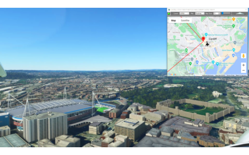
This is the second leg of the Welsh Castles Bush Trip that was created for the Video https://youtu.be/mqZEe50cgws in our How Tos Playlist. This flight plan starts in Cardiff and flies over several castles including Kidwelly before landing at nearby Pembry Airport.
This is the flight plan used in the YouTube video https://youtu.be/RRhKymPCB84
EGFF-EGFP Cardiff to Pembry
Asobo NXCub
EGFF: CARDIFF AIRPORT
USR01: [35.05 NM] WEOBLEY CASTLE
USR02: [8.59 NM] KIDWELLY CASTLE
EGFP: [1.59 NM] PEMBREY AIRPORT
Total Distance: 45.24 NM
Flightplan by texstan
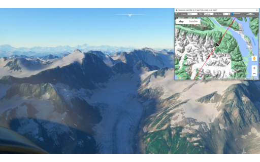
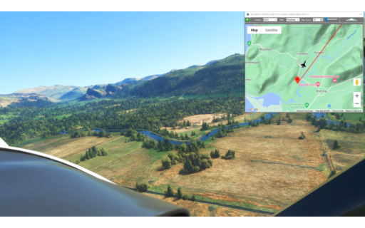
This is the 19th leg of the Pacific Northwest Series and flies over the vast Glacier Bay National Park, Alaska. Take off from Skagway and climb over the 9-10,000 foot peaks and follow the glaciers to the Pacific coast. You’ll need a sharp eye to spot East Alsek River Airstrip in the thick forest.
This is the flight plan from the YouTube video https://youtu.be/qUByGt7WW7o
PAGY-AK76 Skagway to East Alsek River
DA40-NG Asobo
PAGY: SKAGWAY AIRSTRIP
WP1: [42.95 NM] MUIR INLET
WP2: [30.86 NM] GLACIER BAY NATIONAL PARK
WP3: [14.59 NM] MT SALSIBURY
WP4: [25.64 NM] MT HAY
AK76: [25.89 NM] EAST ALSEK RIVER AIRSTRIP
Total Distance: 139.95 NM
Flightplan by texstan
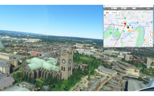
This is the first leg of the Welsh Castles Bush Trip that was created for the YouTube Video https://youtu.be/mqZEe50cgws. This flight plan starts in Gloucestershire England and lands in Cardiff with Waypoints for several castles including Cardiff and Raglan, but there are addtional Castles and Cathedrals to be found along the way.
This is the flight plan used in the YouTube video https://youtu.be/SbdZ2pGd8Z4
EGBJ-EGFF Gloucestershire to Cardiff
Asobo NXCub
EGBJ: GLOUCESTERSHIRE AIRPORT
USR01: [14.50 NM] PURTON SHIP GRAVEYARD
USR02: [6.84 NM] ST BRIAVELS CASTLE
USR03: [8.04 NM] RAGLAN CASTLE
USR04: [20.68 NM] CASTELL COCH
USR05: [4.14 NM] CARDIFF CASTLE
EGFF: [7.91 NM] CARDIFF AIRPORT
Total Distance: 62.13 NM
Flightplan by texstan
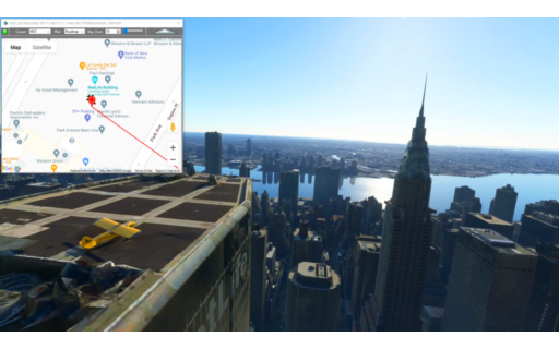
This flight plan demostrates how you can spawn anywhere on earth. It starts spawned at the top of the Metlife Building in New York City in the Savage Cub. It is possible to take off from there and fly past the Chrysler Building while picking up speed.
This is the flight plan used in the YouTube video https://youtu.be/ijdLmAWIygU
Metlife Building, NYC to JFK International
Asobo Savage Cub
MET: MET LIFE BUILDING
KJFK: [11.76 NM] JFK INTERNATIONAL AIRPORT
Total Distance: 11.76 NM
Flightplan by texstan