
Flight Plan Series
Download and fly as many flight plans as you like! Just download and unzip the flight plan files and open them in Microsoft Flight Simulator – World Map, or use Simflightplan™ to change your aircraft, modify waypoints or create your own flight plans and share them here. Happy Flying!
Check out the Frequently Asked Questions page or our YouTube Channel.
You can search for specific flight plans by city/place names or ICAO code or even by author name to find your own or your friends flight plans.
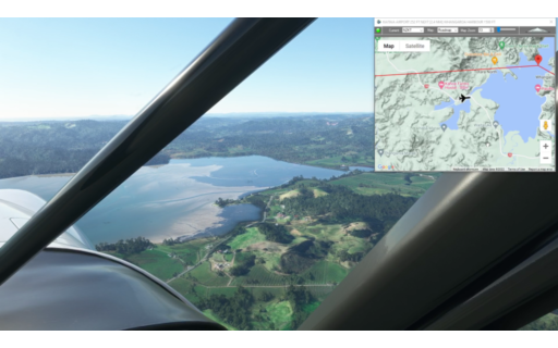
This flight plan is the 4th leg of the Lord of the Rings series. There are no filming locations on this flight plan, it is a scenic flight across the center of the North Island of New Zealand from Rotorua to Taumarunui Airport.
This is the flight plan from the preview video https://youtu.be/RWPrRXZCAvw
Note: In the video the DA40-NGX Improvement Mod has been used which makes the DA40 much easier to fly – you can check it out at https://flightsim.to/file/2738/da40-ngx-project
Thank you to mrtommymxr for the excellent mod.
NZRO-NZTM Rotorua to Taumarunui Airport
DA40-NG Asobo
NZRO: ROTORUA REGIONAL AIRPORT
WP1: [12.39 NM] HOROHORO
WP2: [10.92 NM] POHATUROA LAVA DOME
WP3: [17.47 NM] CENTER OF THE NORTH ISLAND
WP4: [11.75 NM] MARAMATAHA RIVER
NZTM: [15.06 NM] TAUMARUNUI AIRPORT
Total Distance: 67.61 NM
Flightplan by texstan

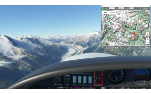
This is leg 8 of the Pacific Northwest series and is the first back-country water landing. The flight plan starts at Tsuniah Lake and winds through the mountains and glaciers to Knight Inlet for a water landing. The XCub Floats is preselected, but there are several capable aircraft in the standard version of Microsoft Flight Simulator so take your pick.
This is the flight plan used in the video https://youtu.be/eTrCepCnbVk
CAF4 to CYBD Tsuniah Lake to Knight Inlet
Asobo XCub Floats
CAF4: TSUNIAH LAKE
WP1: [11.08 NM] TATLAYOKO LAKE
WP2: [9.02 NM] CLOUD DRIFTER PEAK
WP3: [10.88 NM] MOSELY CREEK
WP4: [14.93 NM] UNICORN MOUNTAIN
WP5: [16.52 NM] JUBILEE MOUNTAIN
WL: [11.56 NM] KNIGHT INLET LANDING
Total Distance: 74.02 NM
Flightplan by texstan
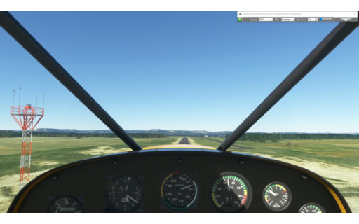
This flight plan is a shortened version of the Badlands to Devils Tower which lands at Custer County Airport just south of the Crazy Horse Memorial.
This is the flight plan used in the video https://youtu.be/CAKlB0f0Dto
KRAP-KCUT Badlands and Mt Rushmore
Asobo Savage Cub
KRAP: RAPID CITY REGIONAL
WP1: [38.02 NM] THE BADLANDS
WP2: [17.38 NM] SHEEP MOUNTAIN OVERLOOK
WP3: [15.36 NM] RED SHIRT TABLE
WP4: [30.30 NM] MT RUSHMORE
WP5: [7.60 NM] CRAZY HORSE MEMORIAL
KCUT: [6.27 NM] CUSTER COUNTY AIRPORT
Total Distance: 114.96 NM
Flightplan by texstan
The is the 7th leg in our Pacific Northwest series. It begins in Squamish, BC (just north of Vancouver) and flies through the mountains and glaciers of British Columbia, Canada and lands at Tsuniah Lake Lodge, just off of Chilko Lake.
Note: In the video the DA40-NGX Improvement Mod has been used which makes the DA40 much easier to fly – you can check it out at https://flightsim.to/file/2738/da40-ngx-project
Thank you to mrtommymxr for the excellent mod.
This is the flight plan used in the YouTube video https://youtu.be/ujc3AEi5mEQ
CYYJ to CAF4 Squamish to Tsuniah Lake
DA40-NG Asobo
CYSE: SQUAMISH AIRPORT
WP1: [6.62 NM] MT TANTALUS
WP2: [8.65 NM] CLOUDBURST MOUNTAIN
WP3: [19.82 NM] DESERTED PEAK
WP4: [29.19 NM] PLINTH PEAK
WP5: [32.13 NM] MT RALEIGH
WP6: [15.86 NM] CHILKO LAKE
CAF4: [26.26 NM] TSUNIAH LAKE LODGE AIRPORT
Total Distance: 138.55 NM
Flightplan by texstan

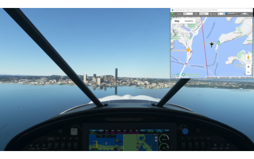
This is the third leg of the Lord of the Rings flight plans. This flight plan starts in Auckland, NZ and continues south to Hobbiton where the portions of several of the Lord of the Rings movies were filmed – according to the NZ tourism website. You will land at Rotorua Regional located on a volcanic crater lake.
Note: In the video the DA40-NGX Improvement Mod has been used which makes the DA40 much easier to fly – you can check it out at https://flightsim.to/file/2738/da40-ngx-project
Thank you to mrtommymxr for the excellent mod.
NZAA-NZRO Auckland Airport to Rotorua
DA40-NG Asobo
NZAA: AUCKLAND AIRPORT
WP1: [21.75 NM] MANGATANGI RESEVOIR
WP2: [19.72 NM] LAKE WAIKARE
LR1: [33.85 NM] LOTR – HOBBITON
WP3: [11.62 NM] KAIMAI MAMAKU LOOKOUT
NZRO: [23.08 NM] ROTORUA REGIONAL AIRPORT
Total Distance: 110.03 NM
Flightplan by texstan

This flight plan explores the Badlands of South Dakota as well as Mt Rushmore, The Crazy Horse Memorial and Devils Tower. There is also a surprise Dinosaur In South Dakota to the south of of the flight path before the first waypoint. Check out the YouTube video if you need help finding it.
This is the flight plan used in the YouTube video https://youtu.be/o_ipEpYK6no
KRAP-W43 Badlands and Mt Rushmore
Asobo Savage Cub
KRAP: RAPID CITY REGIONAL
WP1: [38.02 NM] THE BADLANDS
WP2: [17.38 NM] SHEEP MOUNTAIN OVERLOOK
WP3: [15.36 NM] RED SHIRT TABLE
WP4: [30.30 NM] MT RUSHMORE
WP5: [7.60 NM] CRAZY HORSE MEMORIAL
WP6: [14.56 NM] BLACK HILLS NAT’L FOREST
WP7: [50.52 NM] DEVILS TOWER
W43: [7.63 NM] HUELETT MUNICIPAL
Total Distance: 181.41 NM
Flightplan by texstan
This is the second of the New Zealand series of flight plans and features the northeastern coast of the North Island and Auckland. In some flight plans there will be LOTR waypoints which are locations that were used in the Lord of the Rings flims (according to the NZ tourism website) however this flight plan doesn’t contain any Lord of the Rings waypoints,
This is the flight plan used in the YouTube video https://youtu.be/39vbD267s9o
NZWR-NZAA Whangare Airport to Auckland
Asobo XCub
NZWR: WHANGAREI AIRPORT
WP1: [10.05 NM] SMUGGLERS BAY
WP2: [13.56 NM] MANGAWHAI
WP3: [20.90 NM] KAWAU BAY
WP4: [13.52 NM] STANMORE BAY
NZAA: [23.36 NM] AUCKLAND AIRPORT
Total Distance: 81.41 NM
Flightplan by texstan
This is the first of several flight plans that start at the northern tip of New Zealand and cover the lengh of both islands. In some flight plans there will be LOTR waypoints which are locations that were used in the Lord of the Rings flims (according to the NZ tourism website).
This flight plan doesn’t contain any Lord of the Rings waypoints, however it is a scenic flight along the rugged northeastern coast of the North Island of New Zealand.
This is the flight plan used in the video https://youtu.be/osUewN1riVE
NZKT-NZWR Kaitaia Airport to Whangarei
Asobo XCub
NZKT: KAITAIA AIRPORT
WP1: [22.61 NM] WHANGAROA HARBOUR
WP2: [16.61 NM] TE PUNA INLET
WP3: [14.55 NM] CAPE BRETT LIGHTHOUSE
WP4: [15.53 NM] HELENA BAY
NZWR: [20.38 NM] WHANGAREI AIRPORT
Total Distance: 89.69 NM
Flightplan by texstan
In the YouTube video, we show a technique for converting between US and Metric units of measure, or the reverse. Flightplan supports both US Imperial (feet) and Metric (meters) for altitude, so this functionality can also be used as an easy Metric to US (or vice versa) converter.
This flight plan is actually one of the middle legs of a 30 leg trip from Mt Hood, Oregon to Anchorage, Alaska through British Columbia, Yukon Territory and Alaska, including parts of Glacier Bay Nat’l Park. The first 5 legs are already available at https://simflightplan.com/downloads/pacific-nw/ stay tuned for the rest.
This is the flight plan used in the YouTube video https://youtu.be/osUewN1riVE
CAY4-CYXT Hartley Bay to NW Terrace
Asobo XCub Floats
CAY4: HARTLEY BAY SEAPLANE BASE
WP1: [35.34 NM] TENTACLE PEAK
WP2: [14.98 NM] MT HOLT
CYXT: [24.55 NM] NW TERRACE REGIONAL
Total Distance: 74.88 NM
Flightplan by texstan

In the video we demonstrate some features of Flightplan that can assist with off-airport approaches and landings.
This flight plan is actually one of the middle legs of a 30 leg trip from Mt Hood, Oregon north to Anchorage Alaska using several aircraft and including both glacier and water landings and take offs. Search for Pacifc NW in simflightplan.com/downloads to find them all.
This is the flight plan used in the YouTube video https://youtu.be/nSmXyoQwN8A
CYDB-PAMX Burwash Landing to Mt Benkin
Asobo XCub Skis
CYDB: BURWASH LANDING AIRPORT
WP1: [32.46 NM] SPRIING GLACIER PEAK
WP2: [11.94 NM] MT WALDEN
WP3: [22.71 NM] US / CANADA BORDER
GL1: [5.13 NM] MT BENKIN GLACIER LANDING
Total Distance: 72.25 NM
Flightplan by texstan