
Flight Plan Series
Download and fly as many flight plans as you like! Just download and unzip the flight plan files and open them in Microsoft Flight Simulator – World Map, or use Simflightplan™ to change your aircraft, modify waypoints or create your own flight plans and share them here. Happy Flying!
Check out the Frequently Asked Questions page or our YouTube Channel.
You can search for specific flight plans by city/place names or ICAO code or even by author name to find your own or your friends flight plans.
This flight plan is really just an edited version of the France Bush Trip first leg. In the video we show you how to use Flightplan to assist with Bush Trip navigation both with and without the route laid out on the map.
This is the flight plan used in the YouTube How To video https://youtu.be/jKOD-GQM9sA
Also see https://youtu.be/beZ4-5iuq1w for another bush trip example.
Note: In the video the DA40-NGX Improvement Mod has been used which makes the DA40 much easier to fly – you can check it out at https://flightsim.to/file/2738/da40-ngx-project
Thank you to mrtommymxr for the excellent mod.
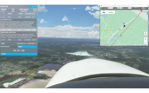
LFCS-LFCH Bordeaux to Arcachon-La Teste-de-Buch
DA40-NG Asobo
LFCS: BORDEAUX AIRPORT
POI1: [7.14 NM] A63 MOTORWAY
POI2: [5.86 NM] A63-A660 JUNCTION
POI3: [8.75 NM] ARCACHON BAY
POI4: [8.24 NM] CAP FERRET LIGHTHOUSE
POI5: [4.14 NM] DUNE DU PILAT
LFCH: [4.51 NM] ARCACHON-LA TESTE AIRPORT
Total Distance: 38.68 NM
Flightplan by texstan
In this video we convert a Bush Trip into a free flight flight plan which we can then customize however we want. Change the aircraft, add, remove or move waypoints and change how and where you spawn in game.
Note: In the video the DA40-NGX Improvement Mod has been used which makes the DA40 much easier to fly – you can check it out at https://flightsim.to/file/2738/da40-ngx-project
Thank you to mrtommymxr for the excellent mod.
This is the flight plan used in the YouTube video https://youtu.be/PJcd1Q4j60w
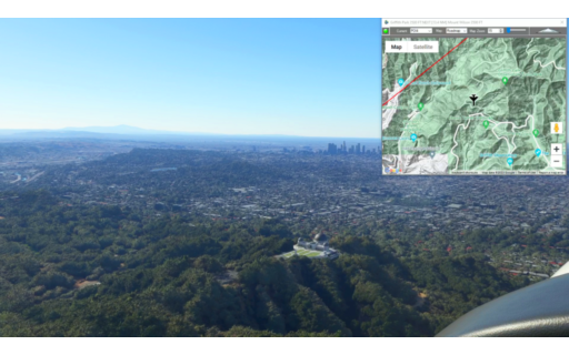
KAVX-KPMD Catalina to Palmdale
DA40-NG Asobo
KAVX: Catalina
POI1: [20.06 NM] Long Point
POI2: [6.54 NM] Torrance
POI2_0: [13.77 NM] LA BREA TAR PITS
POI3: [2.83 NM] GRAYSTONE MANSION
POI3_0: [3.35 NM] HOLLYWOOD BOWL
POI4: [2.33 NM] Griffith Park
POI5: [13.07 NM] Mount Wilson
POI6: [22.78 NM] Blackbird Airpark
KPMD: [1.60 NM] Palmdale Usaf Plant 42
Total Distance: 86.36 NM
Flightplan by texstan
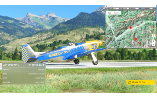
In this video we show you how to change the aircraft on a flight plan to any aircraft that’s not already in the drop-down list. In the example we use the 2nd leg of the Alpine Bush Trip as a flight plan and change the aircraft from the X-Cub to the Mustang P-51D that comes with the Reno Air Races.
*Please note: You must own the Reno Air Races Mustang P-51D to fly this flight plan as-is. Otherwise you can use the video to help you change it to another aircraft (or select one of the standard aircraft from the list of course).
This is the flight plan used in the YouTube video https://youtu.be/70K-JHIlAOQ
LSGS-LSPM Sion to Ambri
P51-D Mustang Asobo Reno
LSGS: Sion
POI13: [8.95 NM] Grande Dixence Dam/Lac Des Dix
POI14: [12.32 NM] Matterhorn
POI15: [5.28 NM] Gornergrat South Observatory
POI16: [4.41 NM] Monte Rosa
DOM: [9.49 NM] Dom
VISP: [11.86 NM] Visp
POI17: [12.07 NM] Aletsch Glacier
POI18: [7.37 NM] Sphinx Observatory
EIGER: [1.98 NM] Eiger
POI19: [17.43 NM] Tiefenstock
POI20: [9.72 NM] Airolo
LSPM: [3.62 NM] Ambri
Total Distance: 104.58 NM
Flightplan by texstan

In the video we use the satellite view of Flightplan to find our house. We then use Cockpit Map to fly the flight plan and show you how to add waypoints on-the-fly.
This is the flight plan used in the YouTube video https://youtu.be/0NPcjYF6N3A
KTVL to KTVL Lake Tahoe
Asobo XCub
KTVL: LAKE TAHOE AIRPORT
HOME: [17.36 NM] MY HOUSE (NOT REALLY)
WP1: [10.72 NM] SECRET COVE NUDE BEACH
KTVL: [15.84 NM] LAKE TAHOE AIRPORT
Total Distance: 43.94 NM
Flightplan by texstan
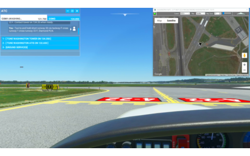
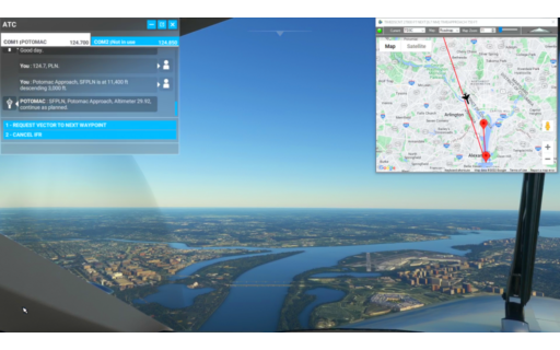
The video demostrates using Cockpit Map to help you taxi from parking to runway 33 at KDCA Washington Nat’l using the real-time satellite view to identify the taxiway markings. Use this flight plan to try it out for yourself in Microsoft Flight Simulator 2020.
Note: In the video the DA40-NGX Improvement Mod has been used which makes the DA40 much easier to fly – you can check it out at https://flightsim.to/file/2738/da40-ngx-project
Thank you to mrtommymxr for the excellent mod.
This is the flight plan used in the YouTube Video:How To Use Satellite View to Assist During Taxi https://youtu.be/-soO3WTJ8oo
KDCA to KBWI Washington Nat’l to Baltimore/Wash Int’l
DA40-NG Asobo
KDCA: WASHINGTON NAT’L
KBWI: [25.95 NM] BALTIMORE/WASHINGTON INT’L
Total Distance: 25.95 NM
Flightplan by texstan
At the completion of this flight, the ‘My Way’ badge popped as I entered the correct gate. I had tried a number of times before so below is the list of things I was careful to do during this flight. I left the “TIMECLIMB, TIMECRUISE…etc” waypoints in the flight plan because I didn’t want to change anything about it since it worked for the “My Way” badge, but they’re not important I don’t think.
One odd thing that happened (not sure if it was related to the flight plan or not) is that ATC dropped me in altitude from 3500′ down to 500′ basically calling out the glide slope descending from the North on a straight in approach to 19 (which I wanted). But ATC never gave me landing clearance for 19, so I basically buzzed the airport and continued south until ATC put me on an approach for runway 01 – which I followed. I never called a missed approach because ATC never gave me landing clearance, I just held at 500 for the length of the runway and then began climbing until ATC finally contacted me again.
I also kept checking my “Assistance” menu to make sure it was still set to True-To-Life. If you miss an ATC call, or accidentally close the Checklist or ATC windows (you can minimize them just don’t close them), it will reset your Assistance options to “Custom”. If that happens you might as well just start over and try to figure out what you did that caused it to flip to Custom. I think in one case I turned off my Landing lights inside of 10NM, but I can’t be sure that was it.
Below is what I did:
*Make sure your Assistance Option is set to ‘True-To-Life’ before loading this flight plan in World Map. If the ATC and Check List windows don’t open when you spawn in the cockpit, you need to reset your Assistance Options and reload the flight plan.
– Follow the checklists to the letter to start the aircraft and prepare to taxi
– Request IFR flight plan clearance from ATC and set the assigned squawk myself & and put assigned altitude into the autopilot
– Turned on Taxi Lights AND Landing Lights before taxi
– Requested Taxi, (didn’t need fuel or pushback)
– Followed Taxi route EXACTLY (Toronto is nice and easy) I was careful to stay right on the yellow lines for the entire route all the way to hold short.
– Do not overrun the hold short line, request take off clearance from ATC, turn off taxi lights.
– Take off when cleared and climb as directed.
– Turn off Landing Lights at +10NM from the airport
– Fly the route as directed using the autopilot as desired
– DO NOT MAKE ATC ASK YOU TWICE!!! Answer ATC first time every time and follow altitude guidance exactly. Respond to aircraft in sight (and make some attempt to sight them)
– Turn on Landing lights before 10NM from the airport.
– Follow ATC guidance on approach into KDCA (again, I got some weird instructions but I don’t know if it will repeat), so I actually had to climb back to 1500 and fly a second approach from the south after my straight-in approach to 19.
– Land and exit the runway ASAP
– Acknowledge ATC, switch to ground freq, ask for a gate (I didn’t try asking for parking) and turn on Taxi Lights (leave Landing Lights on)
– Follow the Taxi route EXACTLY to the gate, stay on the line (luckily KDCA has well painted taxiways and gates, so you can use Satellite view to help make sure you don’t get lost – it should be pretty easy)
– My badge popped as I was nosing onto the line for my gate, but I went ahead and let the ground marshal park me before I exited.
That’s all I can remember about the specific things I was sure to check/do along the way. Unfortunatley I can’t “unpop” the badge to try it again to see what the magic answer was, but hopefully this helps someone.
CYTZ to KDCA Toronto to Washington DC
Beechcraft King Air 350i Asobo
CYTZ: TORONTO CITY AIRPORT
TCLI: [2.69 NM] TIMECLIMB
TCRU: [137.32 NM] TIMECRUIS
TDSC: [29.27 NM] TIMEDSCNT
TAPR: [142.49 NM] TIMEAPPROACH
KDCA: [3.58 NM] WASHINGTON NATIONAL AIRPORT
Total Distance: 315.37 NM
Flightplan by texstan

The video shows a variety of Cockpit Map features you can try out for yourself in this Flightplan from San Franciso Int’l to Hayward Executive Airport.
Note: In the video the DA40-NGX Improvement Mod has been used which makes the DA40 much easier to fly – you can check it out at https://flightsim.to/file/2738/da40-ngx-project
Thank you to mrtommymxr for the excellent mod.
This is the Flightplan used in the YouTube Video:How To Use Flightplans Cockpit Map Features https://youtu.be/ArZW5fIn8qA
San Francisco to Hayward
DA40-NG Asobo
KSFO: SAN FRANCISO INT’L
WP1: [12.97 NM] GOLDEN GATE BRIDGE
WP2: [2.66 NM] ALCATRAZ
KHWD: [17.43 NM] HAYWARD EXECUTIVE AIRPORT
Total Distance: 33.06 NM
Flightplan by texstan

The video shows the Flightplan starting with all systems off. This Flightplan starts with the aircraft started and glass cockpit ready for the flight. You will spawn in the parking spot requested in the video, but check out our video on Changing the Aircraft Position if you want to start in flight.
Note: In the video the DA40-NGX Improvement Mod has been used which makes the DA40 much easier to fly – you can check it out at https://flightsim.to/file/2738/da40-ngx-project
Thank you to mrtommymxr for the excellent mod.
This is the Flightplan used in the YouTube Video: How to Open and Modify a Flightplan https://youtu.be/on3e1gaibuA
San Francisco to Hayward
DA40-NG Asobo
KSFO: SAN FRANCISO INT’L
WP1: [12.97 NM] GOLDEN GATE BRIDGE
WP2: [2.66 NM] ALCATRAZ
KHWD: [17.43 NM] HAYWARD EXECUTIVE AIRPORT
Total Distance: 33.06 NM
Flightplan by texstan

This is the Flightplan used in the YouTube video How to Change The Start Position of Your Aircraft. You can download this flgihtplan and follow along with the video, or fly it yourself just for fun. This Flightplan is saved already in flight over Madrid Airport at 3000 feet, so if you want to take off from the runway, you’ll have to set the Flightplan back on the ground. Watch the video at https://youtu.be/endOVIsYzmA
Note: In the video the DA40-NGX Improvement Mod has been used which makes the DA40 much easier to fly – you can check it out at https://flightsim.to/file/2738/da40-ngx-project
Thank you to mrtommymxr for the excellent mod.
Companion Flightplan for YouTube Video (LEMD to LEVC)
DA40-NG Asobo
LEMD: MADRID-BARAJAS AIRPORT
LEVC: [152.83 NM] VALENCIA AIRPORT
Total Distance: 152.83 NM
Flightplan by texstan

BEST LAP: 1 – 00:03:16
Notre Dame – La Defense Arena
P51-D Mustang Asobo Reno
READY: GET READY
START: [2.22 NM] NOTRE DAME
T1: [0.73 NM] LOUVRE PYRAMID
T2: [0.67 NM] PALAIS GARNIER
T3: [0.98 NM] BASILIQUE DU SACRE-COEUR
T4: [2.70 NM] PONT DE LEVALLOIS
T5: [1.94 NM] PARIS LA DEFENSE ARENA
T6: [0.34 NM] GRAND ARCH OF DEFENSE
T7: [2.59 NM] ARC DE TRIOMPHE
T8: [0.72 NM] PLACE DU TROCADERO
T9: [0.39 NM] EIFFEL TOWER
T10: [0.94 NM] ESPLANADE JACQUES-CHABAN-DELMAS
T11: [0.52 NM] TOUR MONTPARNASSE
T12: [1.01 NM] THE PANTHEON
DONE: [1.78 NM] DONE RACING
Total Distance: 17.61 NM
Flightplan by texstan
OFFICIAL TIMES
BEST [1] – 00:03:16
| WAYPOINT | LAP 1 | LAP 2 |
| START | 7/7/2023 4:38:02 PM |
7/7/2023 4:41:24 PM |
| T1 | 00:00:10 | 00:00:09 |
| T2 | 00:00:08 | 00:00:08 |
| T3 | 00:00:12 | 00:00:12 |
| T4 | 00:00:32 | 00:00:32 |
| T5 | 00:00:31 | 00:00:34 |
| T6 | 00:00:03 | 00:00:04 |
| T7 | 00:00:29 | 00:00:29 |
| T8 | 00:00:36 | 00:00:37 |
| T9 | 00:00:05 | 00:00:04 |
| T10 | 00:00:12 | 00:00:12 |
| T11 | 00:00:06 | 00:00:06 |
| T12 | 00:00:12 | 00:00:12 |
| LAP TIME | 00:03:16 | 00:03:19 |