
Flight Plan Series
Download and fly as many flight plans as you like! Just download and unzip the flight plan files and open them in Microsoft Flight Simulator – World Map, or use Simflightplan™ to change your aircraft, modify waypoints or create your own flight plans and share them here. Happy Flying!
Check out the Frequently Asked Questions page or our YouTube Channel.
You can search for specific flight plans by city/place names or ICAO code or even by author name to find your own or your friends flight plans.

Statue of Liberty – Met Cloisters
P51-D Mustang Asobo Reno Lady B
This is a raceable circuit around Manhattan Island in NYC. Start at the Statue of Liberty, stay below her torch as you fly past then under the Brooklyn and Williamsburg bridges. Then follow the East and Harlem rivers to Yankee Stadium then round the Met Cloisters and head down Broadway to Columbia, Columbus Circle and Madison Square Garden. You’ll have to get to the west coast of the island by Soho to make your run at the World Trade Center and Battery Park before you fly over Ellis Island Immigration Museum to finish the lap… Or round Lady Liberty and see if you can better your time.
READY: GET READY
START: [2.48 NM] STATUE OF LIBERTY
T1: [2.39 NM] BROOKLYN BRIDGE
T2: [1.21 NM] WILLIAMSBURG BRIDGE
T3: [2.74 NM] QUEENSBORO BRIDGE
T4: [1.91 NM] WARDS ISLAND BRIDGE
T5: [1.51 NM] PARK AVENUE BRIDGE
T6: [1.09 NM] YANKEE STADIUM
T7: [1.05 NM] WASHINGTON BRIDGE
T8: [1.10 NM] THE MET CLOISTERS
T9: [1.02 NM] 178TH STREET
T10: [0.42 NM] BROADWAY
T11: [0.59 NM] TRINITY CEMETARY
T12: [1.63 NM] COLUMBIA UNIVERSITY
T13: [1.84 NM] UPPER WEST SIDE
T14: [0.78 NM] COLUMBUS CIRCLE
T15: [1.17 NM] MADISON SQUARE GARDEN
T16: [1.23 NM] GREENWICH VILLAGE
T17: [0.49 NM] SOHO
T18: [0.81 NM] WORLD TRADE CENTER
T19: [0.42 NM] BATTERY PARK
T20: [1.14 NM] ELLIS ISLAND MUSEUM
FINISH: [0.59 NM] FINISH
DONE: [1.40 NM] DONE RACING
Total Distance: 29.15 NM
Flightplan by texstan

LJMB-LJLJ Maribor to Ljubljana
DA 62 Xbox Aviators Club Livery
Leg 1 of the MSFS Upper Northeast Adriatic Countries Bush trip with additional start and stop waypoints added for timing purposes.
LJMB: Maribor
START: [0.58 NM] Start Timing
MARI: [4.59 NM] Maribor
DRAR: [14.13 NM] Drava River
DRAV: [11.38 NM] Dravograd
POLJ: [6.88 NM] Poljana
KORD: [4.57 NM] Kordezeva Glava
SKUT: [12.34 NM] Skuta
END: [9.31 NM] End Timing
LJLJ: [0.18 NM] Ljubljana Joze Pucnik International Airport
Total Distance: 64.01 NM
Flightplan by smoking_hole

LSGS-LSPM Sion to Ambri
Asobo XCub
Leg 3 of the MSFS Grand Alpine Challenge Bush trip with additional start and stop waypoints added for timing purposes.
LSGS: Sion
START: [0.44 NM] Start Timing
POI13: [8.91 NM] Grande Dixence Dam/Lac Des Dix
POI14: [12.32 NM] Matterhorn
POI15: [5.28 NM] Gornergrat South Observatory
POI16: [4.41 NM] Monte Rosa
DOM: [9.49 NM] Dom
VISP: [11.87 NM] Visp
POI17: [12.07 NM] Aletsch Glacier
POI18: [7.37 NM] Sphinx Observatory
EIGER: [1.98 NM] Eiger
POI19: [17.43 NM] Tiefenstock
POI20: [9.72 NM] Airolo
END: [3.28 NM] FInish Timing
LSPM: [0.34 NM] Ambri
Total Distance: 104.98 NM
Flightplan by smoking_hole

LSGB-LSGS Bex to Sion
Asobo XCub
Leg 2 of the MSFS Grand Alpine Challenge Bush trip with additional start and stop waypoints added for timing purposes.
LSGB: Bex
START: [0.13 NM] Start Timing
POI8: [8.28 NM] Tour Salliere
POI9: [3.30 NM] Lac d’Emosson
POI10: [5.97 NM] Aiguille du Tour
POI11: [1.73 NM] Col du Chardonnet
POI12: [8.37 NM] Martigny
STOP: [13.02 NM] Stop Timing
LSGS: [0.13 NM] Sion
Total Distance: 40.96 NM
Flightplan by smoking_hole

Rooster Rock to Eagle Mesa
North American T-6 Texan Asobo Reno Gunslinger
This is a raceable route through the mesas of Monument Valley along the Utah-Arizona border.
READY: GET READY
START: [3.34 NM] ROOSTER ROCK
T01: [1.14 NM] TURN 1
T02: [4.43 NM] THE HUB POINT
T03: [2.78 NM] THE VIEW
T04: [2.26 NM] MITCHELL BUTTE
T05: [4.14 NM] S EAGLE MESA
T06: [0.94 NM] THE STAGECOACH
T07: [2.14 NM] BRIGHAMS TOMB
T08: [0.89 NM] STAGECOACH
T09: [1.37 NM] BIG INDIAN
T10: [2.65 NM] MERRICK BUTTE
FINISH: [6.19 NM] FINISH TIMING
END: [4.70 NM] DONE RACING
Total Distance: 37.03 NM
Flightplan by texstan

The O2 to Westminster Abbey
P51-D Mustang Asobo Reno Goldfinger
This raceable circuit of London starts and finishes at O2 Arena, through Canary Wharf to the Gherkin. Around the Gherkin to St Pauls Cathedral and the BT Tower beyond. Next head south to round Victoria Tower before you head to the Shard and Tower Bridge. Fly through Tower Bridge and follow the Thames to the Royal Naval College where you’ll head north to the O2 Arena and you next lap.
READY: GET READY
START: [3.05 NM] THE O2
T1: [0.74 NM] CANARY WHARF
T2: [2.46 NM] THE GHERKIN
T3: [0.67 NM] ST PAULS CATHEDRAL
T4: [1.58 NM] BT TOWER
T5: [1.47 NM] VICTORIA TOWER
T7: [1.49 NM] THE SHARD
T8: [0.42 NM] TOWER BRIDGE
T10: [2.93 NM] OLD ROYAL NAVAL COLLEGE
FINISH: [1.22 NM] THE O2
DONE: [1.62 NM] DONE RACING
Total Distance: 17.70 NM
Flightplan by texstan

LSGP-LSGB La Cote to Bex
Asobo XCub
This is the first leg of the in-game Grand Alpine Challenge bush trip with additional starting and ending waypoints added for accurate leg timing using the lap timer.
LSGP: La Cote
START: [0.14 NM] Start Timing
POI1: [12.72 NM] Brunswick Monument
POI2: [0.50 NM] Batiment des Forces Motrices
POI3: [1.67 NM] Stade de Geneve
POI4: [4.93 NM] Annemasse
POI5: [10.84 NM] Lake Geneva
POI6: [14.67 NM] Lausanne Cathedral
POI7: [13.70 NM] Chillon Castle
FINISH: [9.70 NM] Finish Timing
LSGB: [0.08 NM] Bex
Total Distance: 69.00 NM
Flightplan by texstan

BEST LAP: 4 – 00:03:10
Notre Dame – La Defense Arena
P51-D Mustang Asobo Reno
This is about a 10 mile circuit of Paris starting on the Seinne River at Notre Dame Cathedral and continues west to the Paris La Defense Arena where you’ll turn around and head back east. Fly through the Grand Arch of Defense over the Arch de Triomph (or through if you dare) and under the Eiffle Tower before heading for the finish line at the Pantheon where you can loop back around Notre Dame to take another lap if you want.
READY: GET READY
START: [2.22 NM] NOTRE DAME
T1: [0.73 NM] LOUVRE PYRAMID
T2: [0.67 NM] PALAIS GARNIER
T3: [0.98 NM] BASILIQUE DU SACRE-COEUR
T4: [2.70 NM] PONT DE LEVALLOIS
T5: [1.94 NM] PARIS LA DEFENSE ARENA
T6: [0.34 NM] GRAND ARCH OF DEFENSE
T7: [2.59 NM] ARC DE TRIOMPHE
T8: [0.72 NM] PLACE DU TROCADERO
T9: [0.39 NM] EIFFEL TOWER
T10: [0.94 NM] ESPLANADE JACQUES-CHABAN-DELMAS
T11: [0.52 NM] TOUR MONTPARNASSE
T12: [1.01 NM] THE PANTHEON
DONE: [1.78 NM] DONE RACING
Total Distance: 17.61 NM
Flightplan by texstan
OFFICIAL TIMES
BEST [4] – 00:03:10
| WAYPOINT | LAP 1 | LAP 2 | LAP 3 | LAP 4 |
| START | 7/8/2023 2:05:50 PM |
7/8/2023 2:09:10 PM |
7/8/2023 2:12:33 PM |
7/8/2023 2:28:55 PM |
| T1 | 00:00:09 | 00:00:09 | 00:00:10 | 00:00:09 |
| T2 | 00:00:08 | 00:00:09 | 00:00:09 | 00:00:08 |
| T3 | 00:00:12 | 00:00:13 | 00:00:11 | 00:00:13 |
| T4 | 00:00:34 | 00:00:33 | 00:00:34 | 00:00:32 |
| T5 | 00:00:38 | 00:00:34 | 00:00:31 | |
| T6 | 00:00:03 | 00:00:04 | 00:00:04 | |
| T7 | 00:00:30 | 00:01:05 | 00:00:28 | 00:00:29 |
| T8 | 00:00:23 | 00:00:32 | 00:00:35 | 00:00:31 |
| T9 | 00:00:04 | 00:00:05 | 00:00:05 | 00:00:05 |
| T10 | 00:00:12 | 00:00:11 | 00:00:10 | 00:00:11 |
| T11 | 00:00:08 | 00:00:06 | 00:00:07 | 00:00:06 |
| T12 | 00:00:11 | 00:00:12 | 00:00:19 | 00:00:11 |
| LAP TIME | 00:03:12 | 00:03:15 | 00:03:26 | 00:03:10 |

This flight plan is a collection of places from the Mysteries of the Abandoned TV show on Science Channel, located along the border of Spain and France including the Canfranc Rail Station high in the mountains. MSFS World Map points of interest for the area are also included as waypoints, including the Mallos de Riglos and PIc du Midi de Bigorre Obseratory near Lourdes.
This is the flight plan used in the YouTube video https://youtu.be/NUokgEokUpo
ES-0165-LFBT Gurrea de Gallego to Lourdes
Asobo NXCub
ES-0165: AERODROMO GURREA de GALLEGO
POI06: [18.89 NM] MALLOS DE RIGLOS
S6E11-3: [22.03 NM] ESCO SPAIN
S2E3-3: [25.30 NM] CANFRANC RAILWAY STATION
POI05: [29.12 NM] LAC DE CAP DE LONG
POI04: [6.93 NM] PIC DU MIDI DE BIGORRE OBSERVATORY
LFBT: [15.96 NM] TARBES-LOURDES AIRPORT
Total Distance: 118.25 NM
Flightplan by texstan
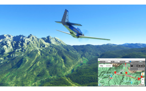
BEST LAP: 1 – 00:04:48
Timed race circuit around Torre Cerrado – check out my lap times. Right up until I slammed into the gorge wall on lap 3.
Parque Nacional de los Picos de Europa
P51-D Mustang Asobo Reno
READY: GET READY
START: [5.27 NM] START TIMING
T1: [2.79 NM] TURN 1
T2: [3.01 NM] TURN 2
T3: [2.77 NM] TURN 3
T4: [1.93 NM] TURN 4
T5: [2.00 NM] TURN 5
T6: [2.14 NM] TURN 6
T7: [2.23 NM] TURN 7
T8: [2.36 NM] TURN 8
T9: [1.93 NM] TURN 9
FINISH: [2.73 NM] STOP TIMING
END: [2.51 NM] END FLIGHT
Total Distance: 31.72 NM
Flightplan by texstan
OFFICIAL TIMES
BEST [1] – 00:04:48
| WAYPOINT | LAP 1 | LAP 2 | LAP 3 |
| START | 6/2/2023 9:05:03 PM |
6/2/2023 9:10:43 PM |
6/2/2023 9:16:52 PM |
| T1 | 00:00:27 | 00:00:29 | 00:00:31 |
| T2 | 00:00:32 | 00:00:32 | 00:00:31 |
| T3 | 00:00:28 | 00:00:29 | 00:00:30 |
| T4 | 00:00:24 | 00:00:30 | 00:00:22 |
| T5 | 00:00:20 | 00:00:22 | |
| T6 | 00:00:26 | 00:00:26 | |
| T7 | 00:00:36 | 00:00:31 | |
| T8 | 00:00:31 | 00:00:33 | |
| T9 | 00:00:26 | 00:00:26 | |
| FINISH | 00:00:38 | 00:01:43 | |
| LAP TIME | 00:04:48 | 00:06:01 |