
Welcome to Simflightplan Racing. Join any of the races below in-flight in MSFS by clicking the checkered flag button in Cockpit Map. If you don’t have Cockpit Map, download Flightplan here. You can also create your own course and upload it, or use any of the uploaded flight plans in the downloads section as a race course to start your own race. The courses below already have active races and ready to use to create your own races. more information
Kings Canyon Circuit
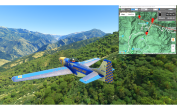
Sequoia National Park
P51-D Mustang Asobo Reno
This is a race course in the Kings Canyon National Park, in the southern Sequioia National Forest.
This is the flight plan used in the YouTube video https://youtu.be/sWh3BRb7rJs
READY: GET READY
START: [2.74 NM] KINGS RIVER SOUTH FORK
T1: [5.11 NM] MIDDLE FORK KINGS RIVER
T2: [4.85 NM] LOST CANYON
T3: [6.71 NM] WINDY CANYON
T4: [3.00 NM] PALISADE CREEK
T5: [4.10 NM] PALISADE LAKE
T6: [2.26 NM] MATHER PASS
T7: [3.17 NM] TABOOSE PASS
T8: [5.74 NM] MURO BLANCO
T9: [2.76 NM] WOODS CREEK
T10: [4.92 NM] BAILEY BRIDGE
T11: [9.20 NM] GRIZZLY FALLS
FINISH: [6.42 NM] LOCKWOOD CREEK
DONE: [2.45 NM] DONE RACING
Total Distance: 63.49 NM
Flightplan by texstan
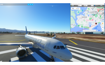
United 154 Pacific Route
United Island Hopper Honolulu to Guam
Airbus A320 Neo Asobo
This is the Pacific route of historic United Flight 154, started by Continental in 1968. It’s an important cargo and mail route in addition to an active passenger route. The flight requires 4 pilots and carries it’s own spare parts and on-board mechanic. It departs Honolulu at 07:25 and ultimately arrives in Guam at 18:25 if the planned departure times are followed. The return leg to Honolulu is not included since its a night leg over open ocean.
The flight plan spawns on the edge of runway 26 R, check your flaps and landing lights and take off for Majuro at 7:25. The departure times from the published United schedule are noted for each airport. Only PHHL and PGUM are airports, the other stops along the way are the correct ICAOs but are User waypoints so as not to confuse MSFS. If you want to file an IFR flight plan with ATC, just use the ICAOs on each waypoint to set a Direct To flight plan from the cockpit.
This flight plan includes start and finish waypoints for race timing
PHNL: HONOLULU INT’L – DEP 07:25
START: [0.21 NM] START TIMING
PMAJ: [1980.16 NM] MAJURO – DEP 11:25
PKWA: [232.63 NM] KWAJALEIN – DEP 13:00
PKSA: [348.50 NM] KOSRAE – DEP 13:55
PPNI: [299.60 NM] POHNPEI – DEP 15:45
PTKK: [380.06 NM] CHUUK / TRUK LAGOON – DEP 16:50
FINISH: [550.37 NM] FINISH TIMING
PGUM: [0.54 NM] GUAM INT’L – ARR 18:25
Total Distance: 3792.11 NM
Flightplan by texstan
Vancouver Circuit
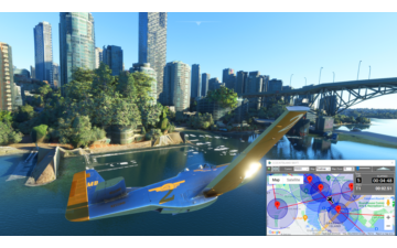
Burrard Street Bridge to Canada Center
P51-D Mustang Asobo Reno Goldfinger
This circuit is a short and fast lap around Vancouver, BC. You’ll have to get under the Burrard St and Granville bridges to start. Next, bank around Science World and spot the gantry cranes at the harbor. Choose your line carefully as you bank over Canada Center, you’ll need to line up Howe St precisely if you’re going to make it to Robson Square and out the other side. One more sharp bank around the Parkview Towers (a black 3 pointed building at the south end of the Burrard St Bridge), then over the hook shaped Elsje Point before you level out over the pier at the Coast Guard Station and line up the Burrard St Bridge for your next lap.
READY: GET READY
START: [1.39 NM] BURRARD ST BRIDGE
T1: [0.22 NM] GRANVILLE BRIDGE
T2: [0.71 NM] CAMBIE BRIDGE
T3: [0.45 NM] SCIENCE WORLD
T4: [0.99 NM] GANTRY CRANE
T5: [0.64 NM] CANADA PLACE
T6: [0.19 NM] WATERFRONT CENTER
T7: [0.47 NM] ROBSON SQUARE
T8: [0.44 NM] PACIFIC STREET
T9: [0.62 NM] PARKVIEW TOWERS
T10: [0.36 NM] ELSJE POINT
FINISH: [0.36 NM] CCGS KITSILANO
END: [1.47 NM] DONE RACING
Total Distance: 8.36 NM
Flightplan by texstan