
Welcome to the downloads page, download and fly as many flight plans as you like. Just download and unzip the flight plan files and open them in Microsoft Flight Simulator World Map, or use Flightplan to change your aircraft, modify waypoints or create your own flight plans and share them here. Check out the FAQ page or our YouTube channel https://youtube.com/@simflightplan for more information.
Happy Flying!
You can search for specific flight plans by city/place names or ICAO code or even by author name to find your own or your friends flight plans. You can also search by series like Pacific Northwest, Lord of the Rings and Navajo Volcanic Field, etc. And if you want to create your own series, just make sure to include the exact same phrase somewhere in your flight plan additional text when you share it (ex. “this is leg xxx of the Pacific Northwest series…”)
|
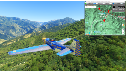
Kings Canyon Circuit |
|
|
Sequoia National Park This is a race course in the Kings Canyon National Park, in the southern Sequioia National Forest. This is the flight plan used in the YouTube video https://youtu.be/sWh3BRb7rJs READY: GET READY Flightplan by texstan |
||

|
Castillion Glide Slope |
|
|
Castillion Landing Practice This landing practice is for Castillion air field in France. It is the first landing after entering the Pyrenees mountains on the Mont Blanc Bush Trip. This flight plan includes 5 waypionts at the appropriate 3° glide slope every 2000 feet to the threshold of the runway (such as it is). *Note: You will probably want to set the Lap Timer Distance Mode to Fixed and set a reasonable distance to each waypoint (ex 200 feet). In normal mode at landing speeds the Normal mode waypoint will be less than 100 feet. START: START FLIGHT CRUISE Flightplan by texstan |
||
|
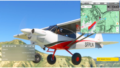
Sedona Landing Practice |
|
|
Runway 21 Glide Slope This is a landing practice for Sedona Airport runway 21. There are 5 glide slope waypoints 2000 feet apart at the correct altitude for a 3° glide slope. *Note: You will probably want to set the Lap Timer Distance Mode to Fixed and set a reasonable distance to each waypoint (ex 200 feet). In normal mode at landing speeds the Normal mode waypoint will be less than 100 feet. READY: READY FLIGHT CRUISE Flightplan by texstan |
||

|
Cincinnati/Northern Ky Intl to Roanoke-Blacksburg Rgnl/Woodru |
|
|
Cincinnati/Northern Ky Intl to Roanoke-Blacksburg Rgnl/Woodru KCVG: KCVG Flightplan by sadkins77 |
||
|
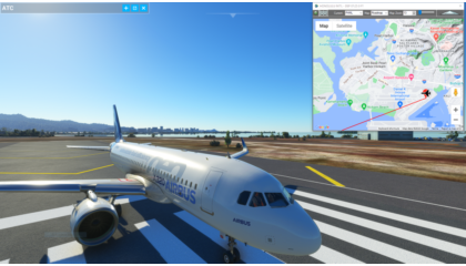
United 154 Pacific Route |
|
|
United Island Hopper Honolulu to Guam This is the Pacific route of historic United Flight 154, started by Continental in 1968. It’s an important cargo and mail route in addition to an active passenger route. The flight requires 4 pilots and carries it’s own spare parts and on-board mechanic. It departs Honolulu at 07:25 and ultimately arrives in Guam at 18:25 if the planned departure times are followed. The return leg to Honolulu is not included since its a night leg over open ocean. The flight plan spawns on the edge of runway 26 R, check your flaps and landing lights and take off for Majuro at 7:25. The departure times from the published United schedule are noted for each airport. Only PHHL and PGUM are airports, the other stops along the way are the correct ICAOs but are User waypoints so as not to confuse MSFS. If you want to file an IFR flight plan with ATC, just use the ICAOs on each waypoint to set a Direct To flight plan from the cockpit. This flight plan includes start and finish waypoints for race timing PHNL: HONOLULU INT’L – DEP 07:25 Flightplan by texstan |
||
|
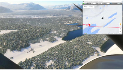
Iditarod 2024 (North Route) |
|
|
Iditarod Air Force Flight Plan This flight plan is the North Route for the world famous Iditarod dog sled race. The North route is used in even years, so this will be the route for 2024. The waypoints are actually placed at the center of the runway if there is an airstrip at the checkpoint itself, ICAO codes are used when available. Otherwise the waypoint is placed at the checkpoint as described in the published route from the Iditarod website at https://iditarod.com/race-map/ where you can find detailed descriptions to find and follow the actual trail. The flight plan files directly between the checkpoints as the Iditarod Air Force bush pilots will be doing in March to resupply the teams and the race officials and provide critical emergency services for both the mushers and the dogs. A weather file (23″ of snow, -13 temp, Sunny and Calm) is included with this flight plan, but for MSFS to find it after downloading the zip file, you will need to open it in Flightplan first. Then save it to a location on your PC using Flightplan. Copying the files out of the downloaded zip file will still provide a flyable flight plan, but the weather file will not autmatically load. This is the flight plan used in the YouTube video https://youtu.be/-PvLcOukmhk PANC: ANCHORAGE INTL AIRPORT Flightplan by texstan |
||

|
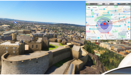
How To Create A Flight Plan in MSFS |
|
|
EGPH-EGRC Edinburgh to Yearby Airstrip This flight plan shows how to create a sight-seeing flight plan using some MSFS World Map points of interest as an example. It is a flight plan from Edinburgh, Scotland to Newcastle, England with waypoints for Edinburgh Castle, HolyroodHouse Palace, Floors Castle and several others. As well as Craigmiller Castle which we found using Google Streets View photogrametry. This is the flight plan used in the YouTube video https://youtu.be/h7m4Gu2rax0 EGPH: EDINBURGH AIRPORT Flightplan by texstan |
||
|
Edinburgh to Yearby Airstrip |
|
|
Edinburgh to Yearby Airstrip This flight plan includes several MSFS World Map points of interest including Edinburg Castle, Tyne Bridge and several more. This is the flight plan used in the YouTube video How To Use Google Maps In MSFS EGPH: EDINBURGH AIRPORT Flightplan by texstan |
||

|
United 154 Pacific Route |
|
|
United Island Hopper Honolulu to Guam This is the Pacifc route of historic United Flight 154, started by Continental in 1968. It’s an important cargo and mail route in addition to an active passenger route. The flight requires 4 pilots and carries it’s own spare parts and on-board mechanic. It departs Honolulu at 07:25 and ultimately arrives in Guam at 18:25 if the planned departure times are followed. The return leg to Honolulu is not included since its a night leg over open ocean. The flight plan spawns on the edge of runway 26 R, check your flaps and landing lights and take off for Majuro at 7:25. The departure times from the published United schedule are noted for each airport. Only PHHL and PGUM are airports, the other stops along the way are the correct ICAOs but are User waypoints so as not to confuse MSFS. If you want to file an IFR flight plan with ATC, just use the ICAOs on each waypoint to set a Direct To flight plan from the cockpit. PHNL: HONOLULU INT’L – DEP 07:25 Flightplan by texstan |
||

|
Mysteries of the Abandoneed – Budapest |
|
|
LHFH-LZPP Budapest to Piestany This flight plan is a collection of places from the Mysteries of the Abandoned TV show on Science Channel, located along the Danube River between Budepest and Bratislava including the Kelenfold Power Station and Cachite Castle. MSFS World Map points of interest for the area are also included as waypoints, including Visegrad Citadel, Bratislava Castle and Estergomi Basilica and Castle. LHFH: FARKASHEGY AIRFIELD Flightplan by texstan |
||