
Welcome to the Flightplan community page, here you can download featured flight plans and see the latest How To videos and articles, plus upcoming product updates and much more. Let us know what you think!
Happy Flying!
Featured Download
|
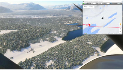
Iditarod 2024 (North Route) |
|
|
Iditarod Air Force Flight Plan This flight plan is the North Route for the world famous Iditarod dog sled race. The North route is used in even years, so this will be the route for 2024. The waypoints are actually placed at the center of the runway if there is an airstrip at the checkpoint itself, ICAO codes are used when available. Otherwise the waypoint is placed at the checkpoint as described in the published route from the Iditarod website at https://iditarod.com/race-map/ where you can find detailed descriptions to find and follow the actual trail. The flight plan files directly between the checkpoints as the Iditarod Air Force bush pilots will be doing in March to resupply the teams and the race officials and provide critical emergency services for both the mushers and the dogs. A weather file (23″ of snow, -13 temp, Sunny and Calm) is included with this flight plan, but for MSFS to find it after downloading the zip file, you will need to open it in Flightplan first. Then save it to a location on your PC using Flightplan. Copying the files out of the downloaded zip file will still provide a flyable flight plan, but the weather file will not autmatically load. This is the flight plan used in the YouTube video https://youtu.be/-PvLcOukmhk PANC: ANCHORAGE INTL AIRPORT Flightplan by texstan |
||
Featured Posts
Newest Flightplans
|
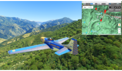
Kings Canyon Circuit |
|
|
Sequoia National Park P51-D Mustang Asobo Reno This is a race course in the Kings Canyon National Park, in the southern Sequioia National Forest. This is the flight plan used in the YouTube video https://youtu.be/sWh3BRb7rJs READY: GET READY START: [2.74… |
||

|
Castillion Glide Slope |
|
|
Castillion Landing Practice DA40-NG Asobo This landing practice is for Castillion air field in France. It is the first landing after entering the Pyrenees mountains on the Mont Blanc Bush Trip. This flight plan includes 5 waypionts at the appropriate… |
||
|
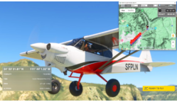
Sedona Landing Practice |
|
|
Runway 21 Glide Slope Asobo NXCub This is a landing practice for Sedona Airport runway 21. There are 5 glide slope waypoints 2000 feet apart at the correct altitude for a 3° glide slope. *Note: You will probably want to set the Lap Timer Distance Mode… |
||